![Cover image](https://images.tarmacs.app/cycling-routes/covers/united-kingdom/berkshire-buckinghamshire-and-oxfordshire/thatcham-5.webp)
Thatcham - Cycling Haven
Cycling routes from Thatcham
Thatcham, situated in Berkshire, Buckinghamshire and Oxfordshire, is a suitable destination for both road and gravel cyclists. With its well-maintained roads and picturesque countryside, Thatcham offers a pleasant cycling experience. A notable cycling-related spot nearby is the North Wessex Downs Area of Outstanding Natural Beauty, providing cyclists with stunning views during their rides. Thatcham ranks 4 on the cyclist perspective scale.
![Map miniature of "Newbury and Thatcham Circular Route" cycling inspiration in Berkshire, Buckinghamshire and Oxfordshire, United Kingdom. Generated by Tarmacs.app cycling route planner](https://images.tarmacs.app/cycling-routes/routemaps/600/united-kingdom/berkshire-buckinghamshire-and-oxfordshire/thatcham/road/62176.webp)
Experience the scenic beauty of Berkshire with a circular route from Thatcham to Newbury and back.
This moderate difficulty route takes you through picturesque countryside, quaint villages, and historical landmarks. Cycling through Thatcham, Newbury, Brightwalton, and East Ilsley, you'll enjoy stunning views along the way. The route is suitable for well-trained amateur cyclists who enjoy a mix of flat and hilly terrain.
![Map miniature of "Gravel Adventure to Walbury Hill" cycling inspiration in Berkshire, Buckinghamshire and Oxfordshire, United Kingdom. Generated by Tarmacs.app cycling route planner](https://images.tarmacs.app/cycling-routes/routemaps/600/united-kingdom/berkshire-buckinghamshire-and-oxfordshire/thatcham/gravel/62270.webp)
Embark on an exciting gravel adventure to the highest point in South East England - Walbury Hill.
This thrilling gravel route takes you through rugged trails and off-road tracks, providing a challenging and rewarding experience. As you conquer the ascent to Walbury Hill, enjoy breathtaking panoramic views of the surrounding countryside. Along the way, you'll also pass through Newbury, Combe, and Thatcham, exploring the unique landscapes of this region.
![Map miniature of "Challenging Road Cycling Adventure from Thatcham" cycling inspiration in Berkshire, Buckinghamshire and Oxfordshire, United Kingdom. Generated by Tarmacs.app cycling route planner](https://images.tarmacs.app/cycling-routes/routemaps/600/united-kingdom/berkshire-buckinghamshire-and-oxfordshire/thatcham/road/62241.webp)
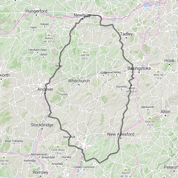
Embark on a challenging road cycling adventure exploring the scenic landscapes near Thatcham.
This road cycling route starting near Thatcham is for experienced cyclists looking for a challenging and rewarding adventure. The route covers a total distance of 127 kilometers with an ascent of 1241 meters, promising breathtaking views and thrilling climbs. With a difficulty level of 5, it's recommended for well-trained cyclists seeking a hardcore challenge.
![Map miniature of "Exploring Pangbourne and Theale Gravel Route" cycling inspiration in Berkshire, Buckinghamshire and Oxfordshire, United Kingdom. Generated by Tarmacs.app cycling route planner](https://images.tarmacs.app/cycling-routes/routemaps/600/united-kingdom/berkshire-buckinghamshire-and-oxfordshire/thatcham/gravel/62243.webp)
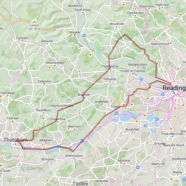
Experience the tranquil beauty of Pangbourne and Theale on this scenic gravel route.
Escape the hustle and bustle of city life and unwind amidst the serene landscapes of Pangbourne and Theale. This moderately challenging gravel route takes you through woodlands, nature reserves, and charming villages. Highlights include Caversham Heights, Theale, and Midgham, offering breathtaking views and a chance to immerse yourself in nature.
![Map miniature of "Thatcham and Beyond Road Cycling Route" cycling inspiration in Berkshire, Buckinghamshire and Oxfordshire, United Kingdom. Generated by Tarmacs.app cycling route planner](https://images.tarmacs.app/cycling-routes/routemaps/600/united-kingdom/berkshire-buckinghamshire-and-oxfordshire/thatcham/road/62220.webp)
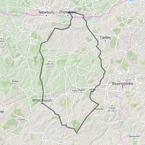
Explore the charming town of Thatcham and its surrounding countryside on this road cycling route.
This road cycling route starting near Thatcham takes you through picturesque villages, stunning countryside, and offers breathtaking views along the way. With a moderate level of difficulty, it's suitable for very well-trained amateur cyclists. The route covers a total distance of 78 kilometers with an ascent of 806 meters, promising an enjoyable and rewarding ride.
![Map miniature of "Hampstead Norreys Gravel Loop" cycling inspiration in Berkshire, Buckinghamshire and Oxfordshire, United Kingdom. Generated by Tarmacs.app cycling route planner](https://images.tarmacs.app/cycling-routes/routemaps/600/united-kingdom/berkshire-buckinghamshire-and-oxfordshire/thatcham/gravel/62230.webp)
Discover the hidden gem of Hampstead Norreys on this exhilarating gravel loop route.
Embark on a thrilling gravel adventure that takes you through diverse landscapes, including woodlands, meadows, and quaint villages. As you cycle through Hampstead Norreys, Blewburton Hill, and Chapel Row, immerse yourself in the natural beauty and rich history of Oxfordshire. The route offers a moderate to challenging level of difficulty, making it perfect for experienced gravel riders.
![Map miniature of "Scenic Ride to Sulhamstead and Aldermaston" cycling inspiration in Berkshire, Buckinghamshire and Oxfordshire, United Kingdom. Generated by Tarmacs.app cycling route planner](https://images.tarmacs.app/cycling-routes/routemaps/600/united-kingdom/berkshire-buckinghamshire-and-oxfordshire/thatcham/gravel/62196.webp)
Embark on a scenic ride through charming villages and picturesque countryside to Sulhamstead and Aldermaston.
This leisurely gravel route offers a pleasant cycling experience, taking you past beautiful landscapes, historical landmarks, and serene nature spots. Pass through Chapel Row, Sulhamstead, and Aldermaston, discovering the unique charm and natural beauty of these areas. With its moderate difficulty level, this route is perfect for cyclists looking for a relaxed and enjoyable ride.
![Map miniature of "Serene Countryside Road Cycling Route" cycling inspiration in Berkshire, Buckinghamshire and Oxfordshire, United Kingdom. Generated by Tarmacs.app cycling route planner](https://images.tarmacs.app/cycling-routes/routemaps/600/united-kingdom/berkshire-buckinghamshire-and-oxfordshire/thatcham/road/62226.webp)
Escape to the serene countryside near Thatcham on this road cycling route.
This road cycling route starting near Thatcham takes you through tranquil countryside and charming villages. With a moderate level of difficulty, it's suitable for experienced cyclists seeking a peaceful but engaging ride. The route covers a total distance of 74 kilometers with an ascent of 587 meters, promising a relaxing and scenic experience.
![Map miniature of "Picturesque Countryside Road Cycling Route from Thatcham" cycling inspiration in Berkshire, Buckinghamshire and Oxfordshire, United Kingdom. Generated by Tarmacs.app cycling route planner](https://images.tarmacs.app/cycling-routes/routemaps/600/united-kingdom/berkshire-buckinghamshire-and-oxfordshire/thatcham/road/62213.webp)
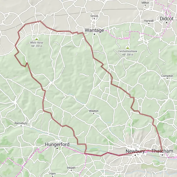
Experience the picturesque countryside near Thatcham on this road cycling route.
This road cycling route starting near Thatcham immerses you in the incredible beauty of the rural countryside. With a moderate level of difficulty, it's perfect for cyclists seeking a balanced and enjoyable ride. The route covers a total distance of 105 kilometers with an ascent of 650 meters, promising stunning views and peaceful surroundings.
![Map miniature of "Scenic Gravel Loop from Thatcham" cycling inspiration in Berkshire, Buckinghamshire and Oxfordshire, United Kingdom. Generated by Tarmacs.app cycling route planner](https://images.tarmacs.app/cycling-routes/routemaps/600/united-kingdom/berkshire-buckinghamshire-and-oxfordshire/thatcham/gravel/62214.webp)
Embark on a gravel adventure through scenic landscapes surrounding Thatcham.
This gravel cycling route starting near Thatcham takes you on an adventurous journey through the countryside and offers breathtaking views. With a moderate level of difficulty, it's perfect for experienced cyclists looking for some off-road excitement. The route covers a total distance of 88 kilometers with an ascent of 760 meters, promising an exhilarating ride.
Cycling routes nearby:
![Image of Cold Ash](https://images.tarmacs.app/cycling-routes/covers/united-kingdom/berkshire-buckinghamshire-and-oxfordshire/cold-ash-5.webp)
![Image of Newbury](https://images.tarmacs.app/cycling-routes/covers/united-kingdom/berkshire-buckinghamshire-and-oxfordshire/newbury-3.webp)
![Image of Hermitage](https://images.tarmacs.app/cycling-routes/covers/united-kingdom/berkshire-buckinghamshire-and-oxfordshire/hermitage-5.webp)
![Image of Winterbourne](https://images.tarmacs.app/cycling-routes/covers/united-kingdom/berkshire-buckinghamshire-and-oxfordshire/winterbourne-5.webp)
![Image of Kingsclere](https://images.tarmacs.app/cycling-routes/covers/united-kingdom/hampshire-and-isle-of-wight/kingsclere-5.webp)
![Image of Highclere](https://images.tarmacs.app/cycling-routes/covers/united-kingdom/hampshire-and-isle-of-wight/highclere-5.webp)
![Image of Tadley](https://images.tarmacs.app/cycling-routes/covers/united-kingdom/hampshire-and-isle-of-wight/tadley-4.webp)
![Image of Compton](https://images.tarmacs.app/cycling-routes/covers/united-kingdom/berkshire-buckinghamshire-and-oxfordshire/compton-5.webp)
Nearby regions:
![Image of Leicestershire, Rutland and Northamptonshire](https://images.tarmacs.app/cycling-routes/covers/united-kingdom/leicestershire-rutland-and-northamptonshire/enderby-2.webp)
![Image of Herefordshire, Worcestershire and Warwickshire](https://images.tarmacs.app/cycling-routes/covers/united-kingdom/herefordshire-worcestershire-and-warwickshire/great-malvern-3.webp)
![Image of Bedfordshire and Hertfordshire](https://images.tarmacs.app/cycling-routes/covers/united-kingdom/bedfordshire-and-hertfordshire/arlesey-4.webp)
![Image of Inner London — West](https://images.tarmacs.app/cycling-routes/covers/united-kingdom/inner-london-west/belsize-park-5.webp)
![Image of Outer London — South](https://images.tarmacs.app/cycling-routes/covers/united-kingdom/outer-london-south/hook-4.webp)
![Image of Outer London — West and North West](https://images.tarmacs.app/cycling-routes/covers/united-kingdom/outer-london-west-and-north-west/harefield-4.webp)
![Image of Hampshire and Isle of Wight](https://images.tarmacs.app/cycling-routes/covers/united-kingdom/hampshire-and-isle-of-wight/portsmouth-4.webp)
![Image of Gloucestershire, Wiltshire and Bristol/Bath area](https://images.tarmacs.app/cycling-routes/covers/united-kingdom/gloucestershire-wiltshire-and-bristol-bath-area/bath-1.webp)