![Cover image](https://images.tarmacs.app/cycling-routes/covers/france/rhone-alpes/saint-egreve-4.webp)
Ideálne miesto pre cyklistiku a gravel biking.
Cyklotrasy od Saint-Egreve
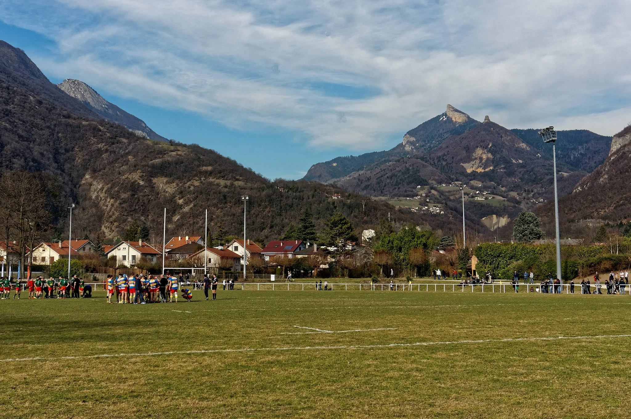
Saint-Égrève je ideálne miesto pre cyklistiku s krásnou prírodou a množstvom cyklotrás. Okolie ponúka rôzne kopcovité úseky, ktoré sú výzvou pre gravel bikerov. Známe cyklistické miesta v blízkosti vrátane slávnych stúpaní na horských cyklistických pretekoch.
![Mapa miniatúra "Scenický okruh Lans-en-Vercors" cyklistická inšpirácia v Rhône-Alpes, France. Vygenerované cyklistickým plánovačom trás Tarmacs.app](https://images.tarmacs.app/cycling-routes/routemaps/600/france/rhone-alpes/saint-egreve/road/207529.webp)
Trasa ponúka úžasné výhľady na pohorie Vercors
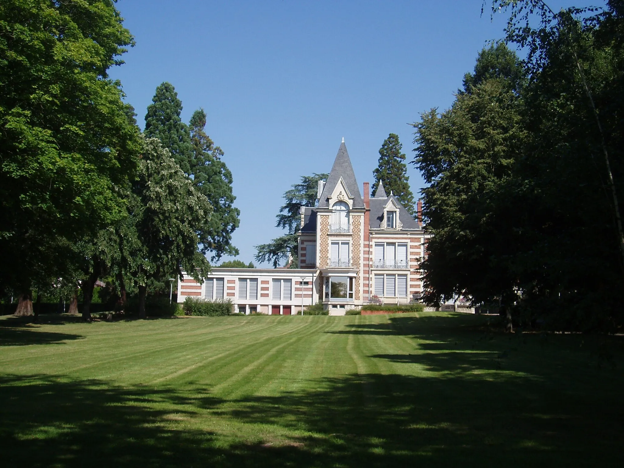
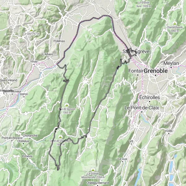
Po 111 km sa ocitnete v Lans-en-Vercors, kde si môžete dopriať oddych v prírodnom prostredí. Okrem toho prejdete cez zaujímavé miesta ako Col d'Herbouilly a Saint-Julien-en-Vercors a navštívite historický objekt Château de la Tourette.
Cyklistický okruh Coteau d'Artets
![Mapa miniatúra "Cyklistický okruh Coteau d'Artets" cyklistická inšpirácia v Rhône-Alpes, France. Vygenerované cyklistickým plánovačom trás Tarmacs.app](https://images.tarmacs.app/cycling-routes/routemaps/600/france/rhone-alpes/saint-egreve/road/207515.webp)
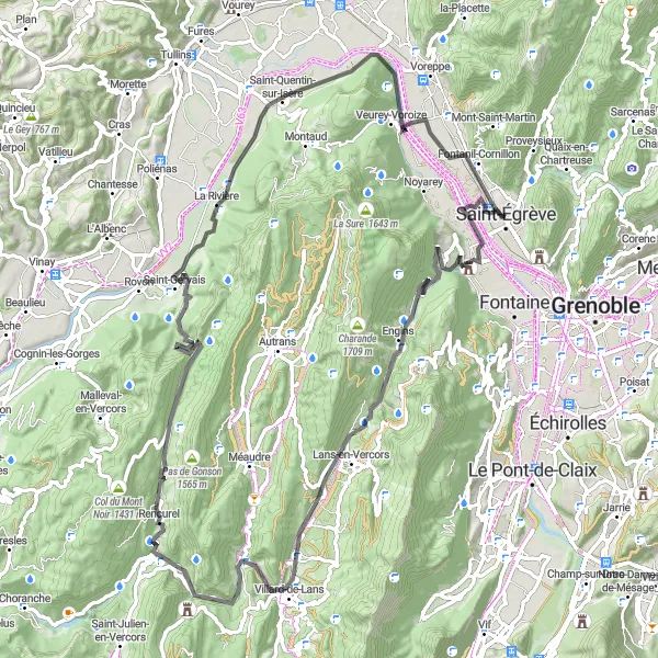
Trasa vedie cez úchvatné prírodné scenérie
Na tomto 89 km dlhom okruhu sa ocitnete v krásnej prírode pohoria Vercors. Prejdete cez historické obce Villard-de-Lans a Veurey-Voroize a navštívite aj skalný útvar Rocher du Cornillon.
![Mapa miniatúra "Gravel prechádzka po Vizzile a Échirolles" cyklistická inšpirácia v Rhône-Alpes, France. Vygenerované cyklistickým plánovačom trás Tarmacs.app](https://images.tarmacs.app/cycling-routes/routemaps/600/france/rhone-alpes/saint-egreve/gravel/207509.webp)
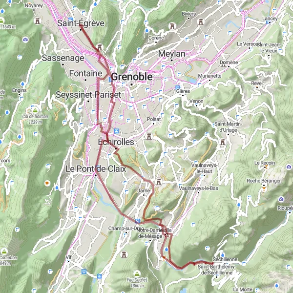
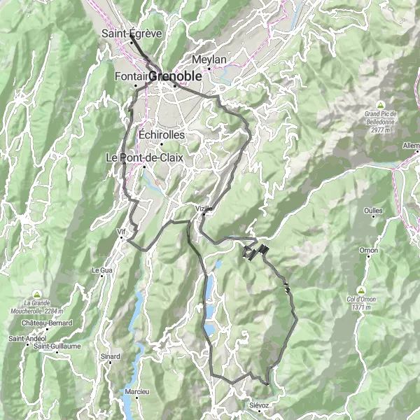
Náročný gravel okruh s historickými pamiatkami a prírodnými scenériami
Tento 63-kilometrový gravel okruh s prevýšením 632 metrov vás zavedie cez historické obce Vizzile a Échirolles. Po ceste si môžete vychutnať pokojné prostredie a krásne prírodné scenérie.
![Mapa miniatúra "Vauban Trail" cyklistická inšpirácia v Rhône-Alpes, France. Vygenerované cyklistickým plánovačom trás Tarmacs.app](https://images.tarmacs.app/cycling-routes/routemaps/600/france/rhone-alpes/saint-egreve/gravel/207622.webp)
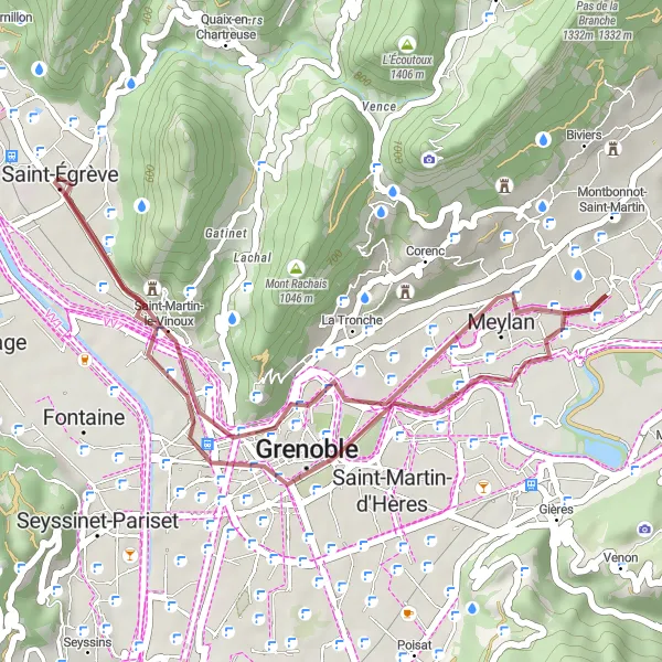
Scenic gravel route with historical landmarks and natural beauty
Discover the beauty of the Rhône-Alpes region on this 29 km gravel cycling route, featuring highlights such as Belvédère Vauban and Pont de Vence. Enjoy the tranquility of the countryside and explore historical sites like La Tronche along the way. The route offers a mix of gravel paths and scenic views, making it ideal for cyclists looking to escape the hustle and bustle of city life.
![Mapa miniatúra "Vercors Graviťák s nádhernými výhľadmi" cyklistická inšpirácia v Rhône-Alpes, France. Vygenerované cyklistickým plánovačom trás Tarmacs.app](https://images.tarmacs.app/cycling-routes/routemaps/600/france/rhone-alpes/saint-egreve/gravel/207517.webp)
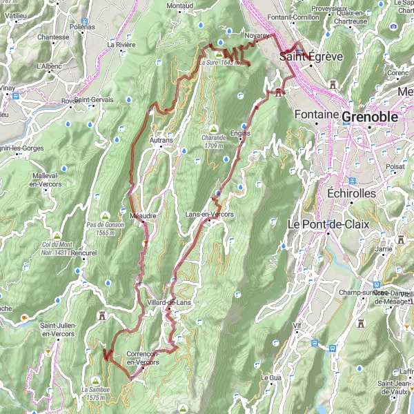
Úžasné výhľady na Vercors
Prejdite náročnými 95 km trasou s prevýšením 2649 m a obdivujte Sassenage, úžasný výhľad, Point de vue Cornafion, Corrençon-en-Vercors, Méaudre, Le Châtelard, La Buffe, La Dent du Loup a Noyarey.
Mont Jalla Circuit
![Mapa miniatúra "Mont Jalla Circuit" cyklistická inšpirácia v Rhône-Alpes, France. Vygenerované cyklistickým plánovačom trás Tarmacs.app](https://images.tarmacs.app/cycling-routes/routemaps/600/france/rhone-alpes/saint-egreve/road/207520.webp)
Breathtaking cycling route with challenging ascents and stunning views
Explore the beautiful Rhône-Alpes region on this 121 km road cycling route, featuring highlights such as Col de la Coche and Rocher du Château. Enjoy the picturesque landscapes and test your skills on the climbs, including Col de la Morte. The route offers a mix of challenging ascents and thrilling descents, making it a must-try for cycling enthusiasts.
Okruh Tour des Templiers
![Mapa miniatúra "Okruh Tour des Templiers" cyklistická inšpirácia v Rhône-Alpes, France. Vygenerované cyklistickým plánovačom trás Tarmacs.app](https://images.tarmacs.app/cycling-routes/routemaps/600/france/rhone-alpes/saint-egreve/road/218151.webp)
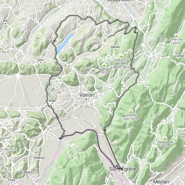
Trasa vedie cez historické zaujímavosti
Tento 109 km dlhý okruh ponúka nádherné výhľady na mesto Apprieu a úchvatné pohorie Vercors. Okrem toho prejdete cez malebné dedinky La Bâtie-Divisin a Saint-Bueil a navštívite aj kláštor Notre-dame du Château a vrchol Col de la Placette.
![Mapa miniatúra "Okruh z Grenoble cez Mont Jalla" cyklistická inšpirácia v Rhône-Alpes, France. Vygenerované cyklistickým plánovačom trás Tarmacs.app](https://images.tarmacs.app/cycling-routes/routemaps/600/france/rhone-alpes/saint-egreve/road/207514.webp)
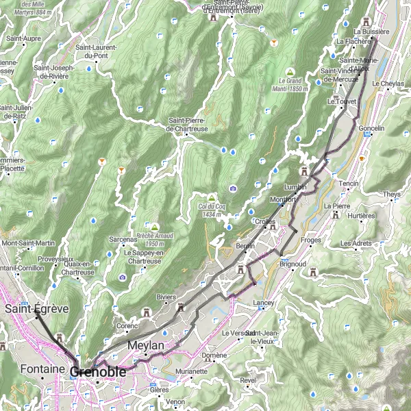
Jazda plná kontrastov a výziev
Prejdite 86 km trasou s prevýšením 563 m a navštívte Mont Jalla, Grenoble, Château de la Veyrie, La Buissière, Montbonnot-Saint-Martin, Belvédère Vauban a Saint-Martin-le-Vinoux.
![Mapa miniatúra "Okruh smerujúci cez Chartreuse de Prémol až do Le Bourg-d'Oisans" cyklistická inšpirácia v Rhône-Alpes, France. Vygenerované cyklistickým plánovačom trás Tarmacs.app](https://images.tarmacs.app/cycling-routes/routemaps/600/france/rhone-alpes/saint-egreve/road/207629.webp)
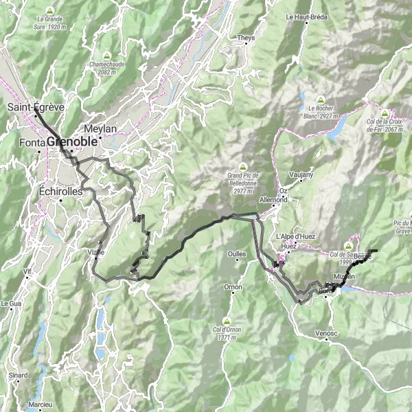
Jazda po malebnej prírode s mnohými historickými pamiatkami
Tento 175-kilometrový okruh s prevýšením 4898 metrov ponúka nádherný výhľad na Chartreuse de Prémol, historický Col Luitel a malé dedinky ako Séchilienne. Cestou sa môžete zastaviť v Le Bourg-d'Oisans, kde vás očarí atmosféra miestnych kaviarní a reštaurácií.
![Mapa miniatúra "Challenging road cycling route through Col de Parménie" cyklistická inšpirácia v Rhône-Alpes, France. Vygenerované cyklistickým plánovačom trás Tarmacs.app](https://images.tarmacs.app/cycling-routes/routemaps/600/france/rhone-alpes/saint-egreve/road/207555.webp)
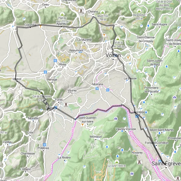
Exciting journey through picturesque villages and stunning natural landscapes
This 76-kilometer road cycling route with an ascent of 751 meters takes you through scenic villages and the challenging Col de Parménie. Along the way, you can enjoy breathtaking views and experience the beauty of the French countryside.
Cyklistické trasy v okolí:
Blízke regióny:
![Obrázok Région lémanique](https://images.tarmacs.app/cycling-routes/covers/switzerland/region-lemanique/montreux-5.webp)
![Obrázok Espace Mittelland](https://images.tarmacs.app/cycling-routes/covers/switzerland/espace-mittelland/wohlen-4.webp)
![Obrázok Bourgogne](https://images.tarmacs.app/cycling-routes/covers/france/bourgogne/talant-4.webp)
![Obrázok Franche-Comté](https://images.tarmacs.app/cycling-routes/covers/france/franche-comte/vieux-charmont-5.webp)
![Obrázok Languedoc-Roussillon](https://images.tarmacs.app/cycling-routes/covers/france/languedoc-roussillon/saint-gely-du-fesc-5.webp)
![Obrázok Auvergne](https://images.tarmacs.app/cycling-routes/covers/france/auvergne/saint-germain-des-fosses-3.webp)
![Obrázok Provence-Alpes-Côte d’Azur](https://images.tarmacs.app/cycling-routes/covers/france/provence-alpes-cote-dazur/menton-4.webp)
![Obrázok Piemonte](https://images.tarmacs.app/cycling-routes/covers/italy/piemonte/pernate-3.webp)
![Obrázok Valle d’Aosta/Vallée d’Aoste](https://images.tarmacs.app/cycling-routes/covers/italy/valle-daosta-vallee-daoste/pont-saint-martin-2.webp)