![Cover image](https://images.tarmacs.app/cycling-routes/covers/switzerland/nordwestschweiz/bubendorf-4.webp)
Dobré miesto pre cyklistiku v Nordwestschweiz.
Cyklotrasy od Bubendorf
Bubendorf je oblasť v Nordwestschweiz s rôznymi cyklistickými trasami a terénmi pre cestných aj štrkových cyklistov. Okolie poskytuje niektoré zaujímavé možnosti na jazdu a prieskum. V blízkosti sú aj známe cyklistické body a stúpania.
Okruh cez Bürenflue a Rheinfelden
![Mapa miniatúra "Okruh cez Bürenflue a Rheinfelden" cyklistická inšpirácia v Nordwestschweiz, Switzerland. Vygenerované cyklistickým plánovačom trás Tarmacs.app](https://images.tarmacs.app/cycling-routes/routemaps/600/switzerland/nordwestschweiz/bubendorf/road/155486.webp)
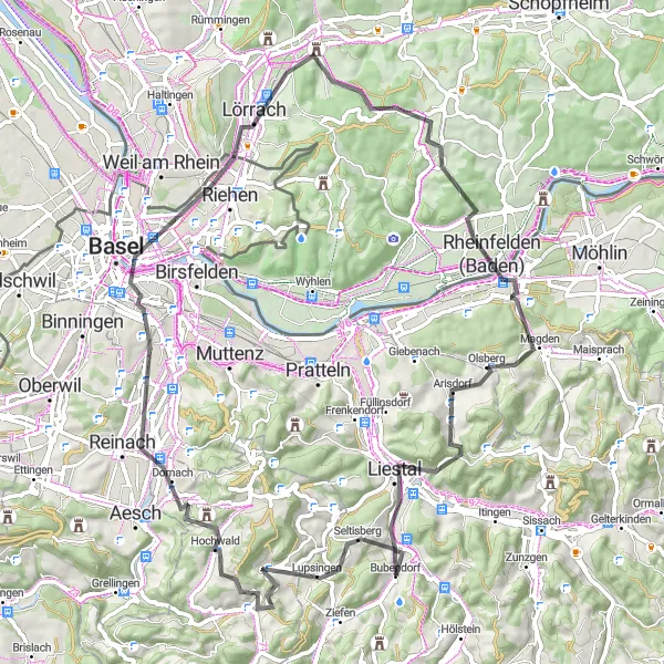
Pestrost horského terénu a malebné výhľady
Cyklistická trasa ponúka 76 km malebného prostredia s výstupmi. Po ceste nájdete historickú Bürenflue, zaujímavé úseky v Hochwalde a Pfalz či pohľady na Rheinfelden a Lörrach.
Gravel Route: Hau - Bubendorf
![Mapa miniatúra "Gravel Route: Hau - Bubendorf" cyklistická inšpirácia v Nordwestschweiz, Switzerland. Vygenerované cyklistickým plánovačom trás Tarmacs.app](https://images.tarmacs.app/cycling-routes/routemaps/600/switzerland/nordwestschweiz/bubendorf/gravel/155427.webp)
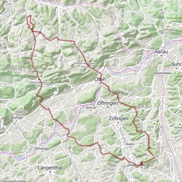
Discover the picturesque villages and lush landscapes on this gravel adventure.
This 97km gravel route takes you through the charming towns of Läufelfingen, Murgenthal, and Waldenburg, offering stunning views of the countryside. With a total ascent of 2672m, this challenging ride is perfect for experienced gravel riders looking for a scenic and rewarding journey.
Z Liestalu na Spitzenberg
![Mapa miniatúra "Z Liestalu na Spitzenberg" cyklistická inšpirácia v Nordwestschweiz, Switzerland. Vygenerované cyklistickým plánovačom trás Tarmacs.app](https://images.tarmacs.app/cycling-routes/routemaps/600/switzerland/nordwestschweiz/bubendorf/road/155498.webp)
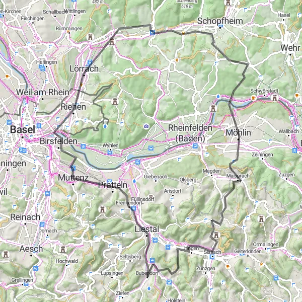
Pestrá trasa s historickými pamiatkami a panoramatickými vyhliadkami
79 km trasa s 1149 m prevýšením ponúka zaujímavé miesta a historické dedinky podél cesty. S highlightami ako Liestal a Maulburg si užijete pestré výhľady na okolitú krajinu.
![Mapa miniatúra "Gravel Route: Galmshöchi - Hölstein" cyklistická inšpirácia v Nordwestschweiz, Switzerland. Vygenerované cyklistickým plánovačom trás Tarmacs.app](https://images.tarmacs.app/cycling-routes/routemaps/600/switzerland/nordwestschweiz/bubendorf/gravel/155424.webp)
Embark on a challenging gravel adventure through the stunning Swiss landscapes.
This 83km gravel route offers a mix of challenging climbs and thrilling descents, with a total ascent of 2180m. Highlights include the picturesque Itingen and the historic town of Bad Säckingen. Suitable for experienced gravel riders seeking a fun and rewarding cycling experience.
Pohorie Egg a Passwang
![Mapa miniatúra "Pohorie Egg a Passwang" cyklistická inšpirácia v Nordwestschweiz, Switzerland. Vygenerované cyklistickým plánovačom trás Tarmacs.app](https://images.tarmacs.app/cycling-routes/routemaps/600/switzerland/nordwestschweiz/bubendorf/road/155566.webp)
Náročná trasa s vysokými výstupmi a odmenou v podobe výhľadov
69 km trasa so 2050 m prevýšením ponúka náročnú výzvu pre cyklistov. S highlightami ako Egg a Passwang sa potešia milovníci horských výstupov a panoramatických výhľadov.
![Mapa miniatúra "Gravelový okruh cez Bettenberg a Disliberg" cyklistická inšpirácia v Nordwestschweiz, Switzerland. Vygenerované cyklistickým plánovačom trás Tarmacs.app](https://images.tarmacs.app/cycling-routes/routemaps/600/switzerland/nordwestschweiz/bubendorf/gravel/155419.webp)
Zážitok z jazdy po neznačených cestách a prírodnom prostredí
66 km trasa so 1928 m prevýšením ponúka dobrodružstvo pre milovníkov cyklistiky v divokej prírode. S highlightami ako Bettenberg a Disliberg si užijete jedinečný zážitok vo vzdialených a tichých horách.
Gravel Route: Strick - Bubendorf
![Mapa miniatúra "Gravel Route: Strick - Bubendorf" cyklistická inšpirácia v Nordwestschweiz, Switzerland. Vygenerované cyklistickým plánovačom trás Tarmacs.app](https://images.tarmacs.app/cycling-routes/routemaps/600/switzerland/nordwestschweiz/bubendorf/gravel/155430.webp)
Embark on a scenic gravel ride through the idyllic Swiss countryside.
This 44km gravel route offers a mix of challenging climbs and thrilling descents, with a total ascent of 1463m. Highlights include the picturesque Geissflue and the charming village of Nunningen. Suitable for intermediate riders looking for a fun and rewarding cycling experience.
Dlhá trasa cez Schachbühl a Hau
![Mapa miniatúra "Dlhá trasa cez Schachbühl a Hau" cyklistická inšpirácia v Nordwestschweiz, Switzerland. Vygenerované cyklistickým plánovačom trás Tarmacs.app](https://images.tarmacs.app/cycling-routes/routemaps/600/switzerland/nordwestschweiz/bubendorf/road/155631.webp)
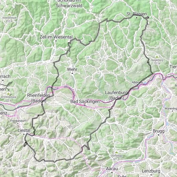
Extrémna výzva s množstvom prevýšení a zaujímavými highlightmi
155 km dlhá trasa s 3235 m prevýšením ponúka cyklistom náročnú výzvu v horskom teréne. Cestou stretnete zaujímavosti ako Schachbühl, Todtmoos a Lehenkopf.
![Mapa miniatúra "Gravel Route: Strick - Horn" cyklistická inšpirácia v Nordwestschweiz, Switzerland. Vygenerované cyklistickým plánovačom trás Tarmacs.app](https://images.tarmacs.app/cycling-routes/routemaps/600/switzerland/nordwestschweiz/bubendorf/gravel/155428.webp)
Discover the hidden gems and scenic beauty on this gravel cycling route.
This 35km gravel route takes you through the idyllic Swiss countryside, with a total ascent of 773m. Highlights include the charming village of Bretzwil and the picturesque Horn. Suitable for all levels of gravel riders looking for a fun and rewarding cycling adventure.
![Mapa miniatúra "Road Route: Itingen - Bubendorf" cyklistická inšpirácia v Nordwestschweiz, Switzerland. Vygenerované cyklistickým plánovačom trás Tarmacs.app](https://images.tarmacs.app/cycling-routes/routemaps/600/switzerland/nordwestschweiz/bubendorf/road/155416.webp)
Experience the scenic beauty of the Swiss countryside on this road cycling adventure.
This 82km road route takes you through the picturesque villages of Oltingen, Oftringen, and Oberdorf BL, with a total ascent of 1626m. Enjoy the smooth roads and stunning views of the rolling hills and lush forests along the way. Perfect for road cycling enthusiasts seeking a challenging yet enjoyable ride.
Cyklistické trasy v okolí:
Blízke regióny:
![Obrázok Région lémanique](https://images.tarmacs.app/cycling-routes/covers/switzerland/region-lemanique/sainte-croix-4.webp)
![Obrázok Espace Mittelland](https://images.tarmacs.app/cycling-routes/covers/switzerland/espace-mittelland/belp-5.webp)
![Obrázok Zürich](https://images.tarmacs.app/cycling-routes/covers/switzerland/zurich/egg-3.webp)
![Obrázok Ostschweiz](https://images.tarmacs.app/cycling-routes/covers/switzerland/ostschweiz/amden-2.webp)
![Obrázok Zentralschweiz](https://images.tarmacs.app/cycling-routes/covers/switzerland/zentralschweiz/meggen-4.webp)
![Obrázok Freiburg](https://images.tarmacs.app/cycling-routes/covers/germany/freiburg/durbach-4.webp)
![Obrázok Tübingen](https://images.tarmacs.app/cycling-routes/covers/germany/tubingen/eningen-unter-achalm-5.webp)
![Obrázok Franche-Comté](https://images.tarmacs.app/cycling-routes/covers/france/franche-comte/levier-2.webp)
![Obrázok Alsace](https://images.tarmacs.app/cycling-routes/covers/france/alsace/rosheim-1.webp)