![Cover image](https://images.tarmacs.app/cycling-routes/covers/switzerland/ostschweiz/sirnach-3.webp)
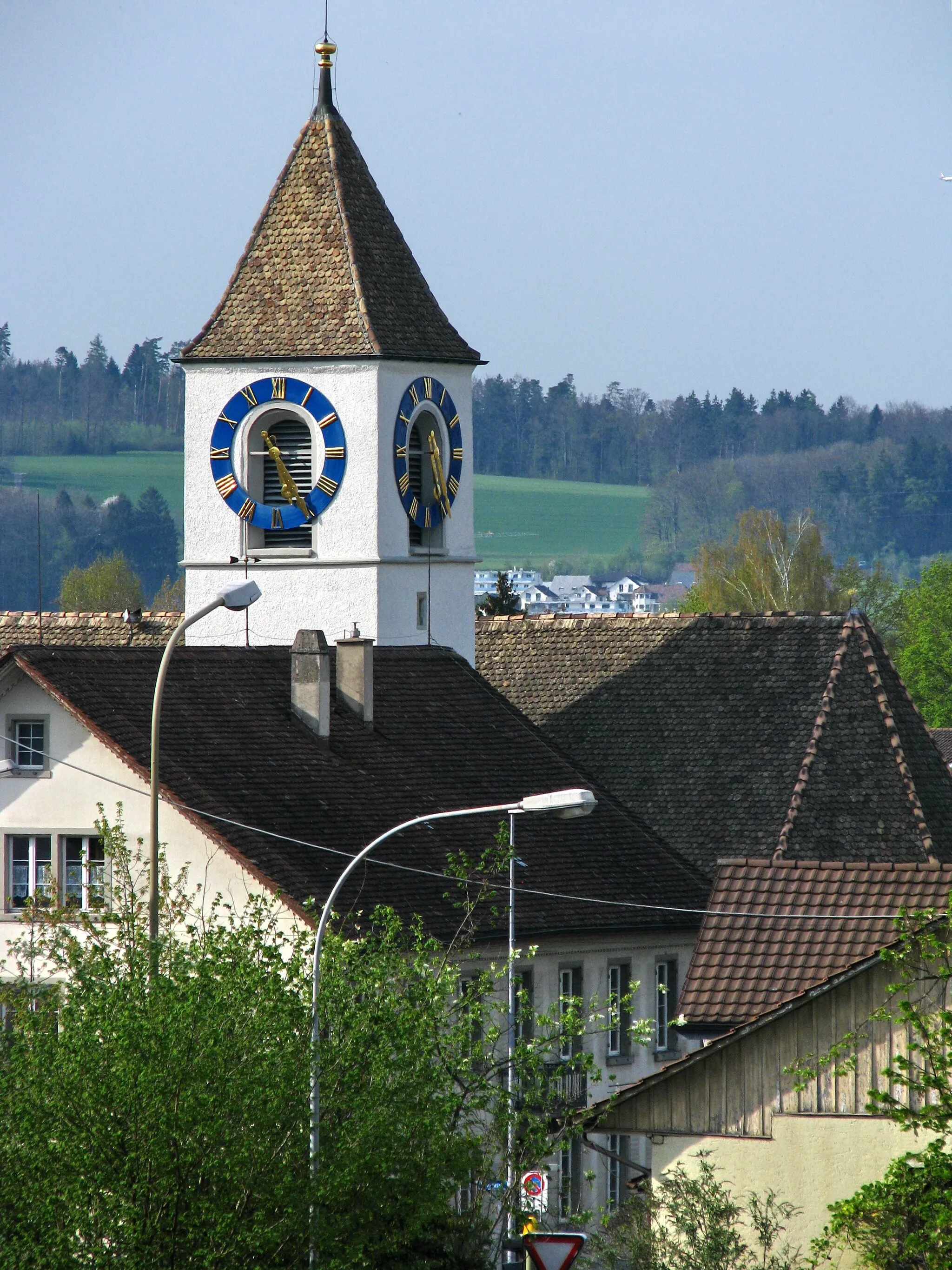
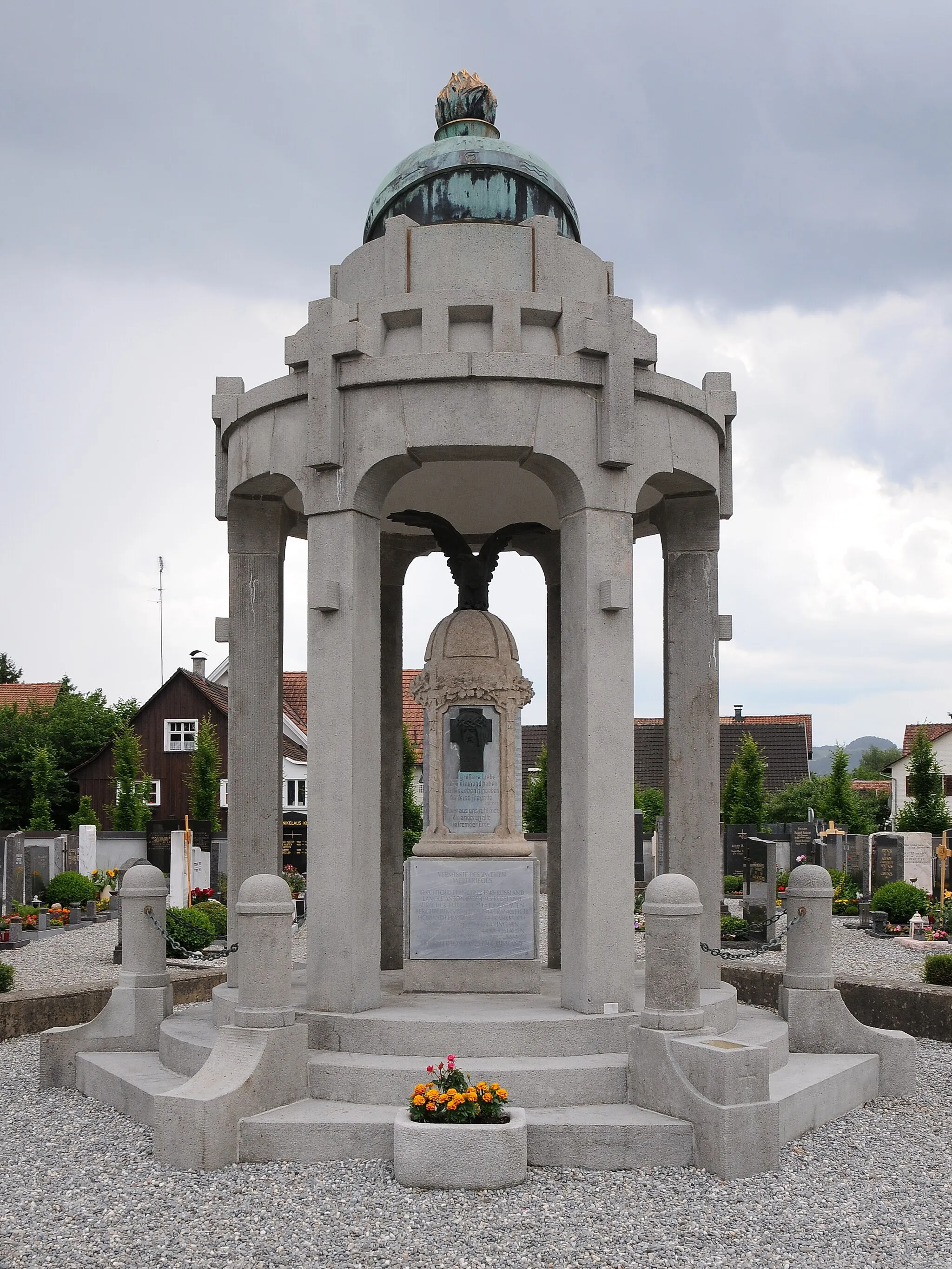
Klidná obec pro cyklistické výlety s možností výjezdu na kopec Hörnli.
Cyklistické trasy kolem Sirnach
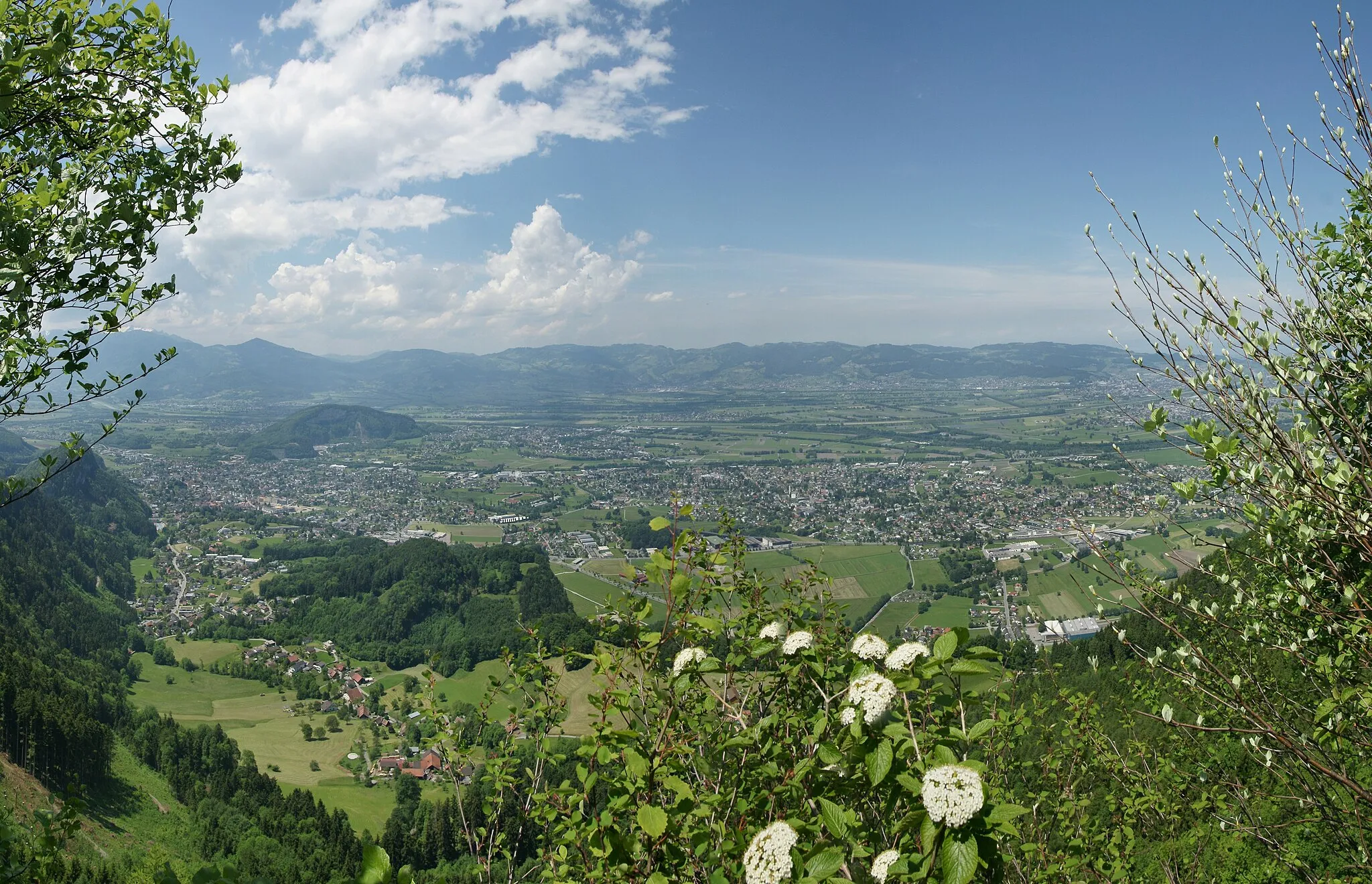
Sirnach je obec v oblasti Ostschweiz ve Švýcarsku. Cyklisté zde najdou klidné cesty a možnost výjezdů do okolní krajiny. Nedaleko se nachází známý kopec Hörnli, oblíbený cíl cyklistů.
![Miniaturní mapa "Gravelová cyklostezka Frauenfeld - Münchwilen TG" inspirace pro cyklisty v oblasti Ostschweiz, Switzerland. Vytvořeno pomocí plánovače tras Tarmacs.app](https://images.tarmacs.app/cycling-routes/routemaps/600/switzerland/ostschweiz/sirnach/gravel/94390.webp)
Poutavá trasa pro milovníky gravelu
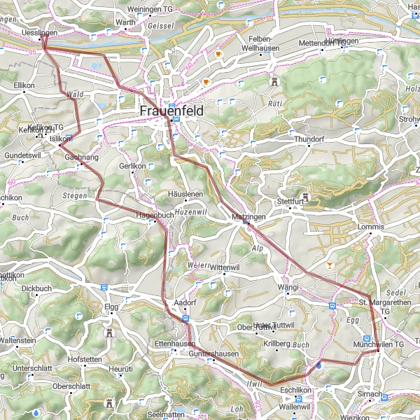
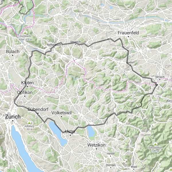
Tato 45 km dlouhá trasa nabízí pestrou krajinu a zajímavé zastávky v městech Frauenfeld, Gachnang a Münchwilen TG. Je ideální pro cyklisty hledající dobrodružství a adrenalin.
![Miniaturní mapa "Gravel Route to Rickenbach" inspirace pro cyklisty v oblasti Ostschweiz, Switzerland. Vytvořeno pomocí plánovače tras Tarmacs.app](https://images.tarmacs.app/cycling-routes/routemaps/600/switzerland/ostschweiz/sirnach/gravel/94375.webp)
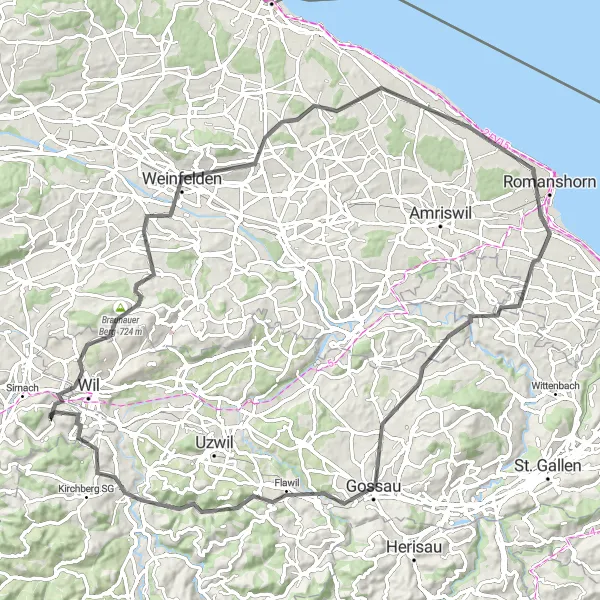
Scenic gravel route with moderate ascent and rural highlights
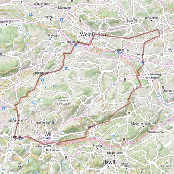
Enjoy a scenic gravel route near Sirnach with moderate ascent and rural highlights. Cycle through Münchwilen TG and Weinfelden before reaching Sulgen. Continue on to Heubuch and Zuzwil SG, passing through picturesque countryside. Finish the route in Rickenbach with a sense of accomplishment.
![Miniaturní mapa "Okolí Sirnachu - Münchwilen Turm" inspirace pro cyklisty v oblasti Ostschweiz, Switzerland. Vytvořeno pomocí plánovače tras Tarmacs.app](https://images.tarmacs.app/cycling-routes/routemaps/600/switzerland/ostschweiz/sirnach/road/94363.webp)
Příjemná jízda s výhledem na okolní kopce
Tato trasa nabízí 58 km krásné krajiny a 610 metrů stoupání. Projdete kolem historických památek jako Münchwilen TG a užijete si malebné vesničky a klidné cesty.
![Miniaturní mapa "Gravel Route to Turbenthal" inspirace pro cyklisty v oblasti Ostschweiz, Switzerland. Vytvořeno pomocí plánovače tras Tarmacs.app](https://images.tarmacs.app/cycling-routes/routemaps/600/switzerland/ostschweiz/sirnach/gravel/94391.webp)
Scenic gravel route with moderate ascent and unique highlights
This gravel route near Sirnach offers beautiful views and a moderate ascent. Pass through Ebnet and Littenheid before reaching the highlight of Waltensberg. Continue on to Turbenthal and experience the natural beauty of the area, ending back in Sirnach.
![Miniaturní mapa "Horská výzva k Hofstettnu" inspirace pro cyklisty v oblasti Ostschweiz, Switzerland. Vytvořeno pomocí plánovače tras Tarmacs.app](https://images.tarmacs.app/cycling-routes/routemaps/600/switzerland/ostschweiz/sirnach/gravel/94372.webp)
Extrémní stezka s úchvatnými výhledy
Tato 93 km dlouhá trasa nabízí 1598 m stoupání a nádherné výhledy na okolní kopce a údolí. Projedete kolem malebných vesnic jako Fischingen a Hörnli a oceníte krásu krajiny okolo Rüti ZH a Mönchaltorfu.
![Miniaturní mapa "Cyklostezka Trunger Holz - Altstadthügel" inspirace pro cyklisty v oblasti Ostschweiz, Switzerland. Vytvořeno pomocí plánovače tras Tarmacs.app](https://images.tarmacs.app/cycling-routes/routemaps/600/switzerland/ostschweiz/sirnach/road/94374.webp)
Malebná trasa s historickými skvosty
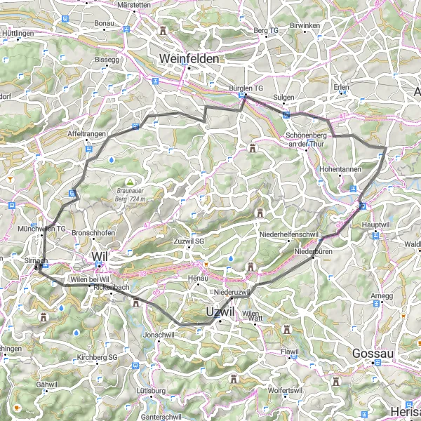
Tato 77 km dlouhá cyklostezka vede přes malebné vesnice a historická místa jako Trunger Holz, Bürglen TG a Rickenbach. Je vhodná pro cyklisty se zájmem o regionální historii a architekturu.
![Miniaturní mapa "Gravelová stezka k Rickenbachu" inspirace pro cyklisty v oblasti Ostschweiz, Switzerland. Vytvořeno pomocí plánovače tras Tarmacs.app](https://images.tarmacs.app/cycling-routes/routemaps/600/switzerland/ostschweiz/sirnach/gravel/139263.webp)
Náročná trasa s krásnými výhledy do kopců
Tato 72 km dlouhá cesta s převýšením 1054 m vás zavede přes malebné vesnice a lesní stezky. Užijete si krásné výhledy na Affeltrangen a Bommen a projedete kolem úchvatné přírody okolí Rickenbachu.
![Miniaturní mapa "Cyklostezka Sternenberg - Eschlikon" inspirace pro cyklisty v oblasti Ostschweiz, Switzerland. Vytvořeno pomocí plánovače tras Tarmacs.app](https://images.tarmacs.app/cycling-routes/routemaps/600/switzerland/ostschweiz/sirnach/road/94373.webp)
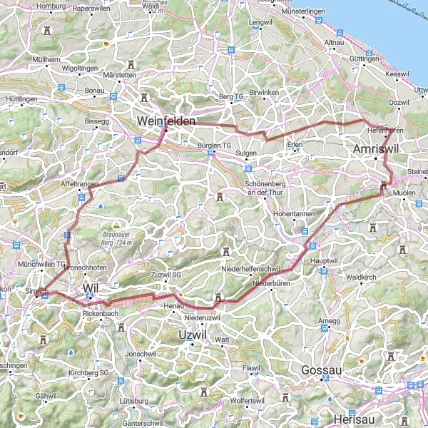
Významná cyklostezka s nádhernými výhledy
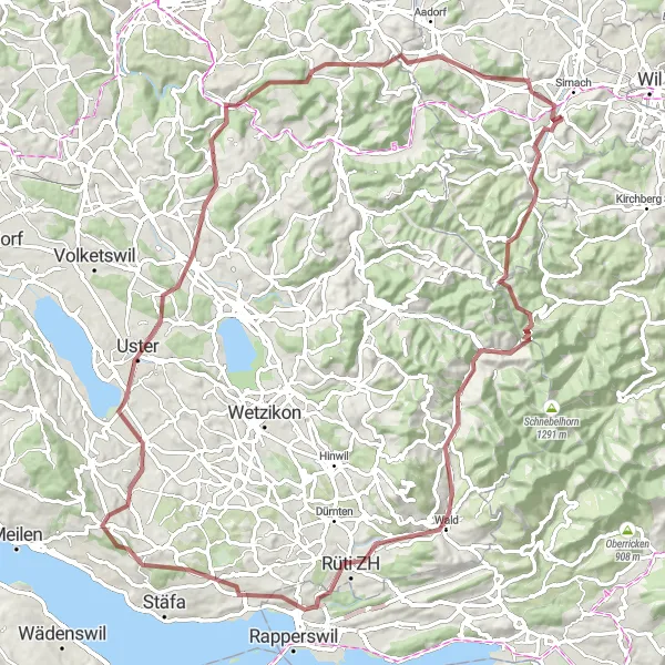
Tato 104 km dlouhá cyklostezka nabízí panoramatické výhledy na Pfäffikersee a je ideální pro milovníky silniční cyklistiky. Trasa vede přes zajímavá místa jako Sternenberg, Uster a Aussichtsturm.
![Miniaturní mapa "Gravelová cesta k Jubla Turm Sirnach" inspirace pro cyklisty v oblasti Ostschweiz, Switzerland. Vytvořeno pomocí plánovače tras Tarmacs.app](https://images.tarmacs.app/cycling-routes/routemaps/600/switzerland/ostschweiz/sirnach/gravel/139216.webp)
Nádherná trasa skrze malebnou krajinu
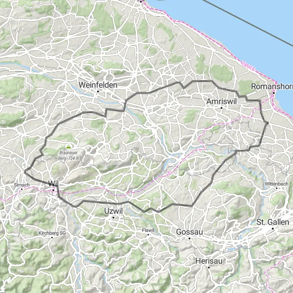
Tato 72 km dlouhá cesta s převýšením 657 m vás zavede přes úchvatné scenérie a klidné vesnice. Užijete si pohled na Trunger Holz a Bussnang a projedete kolem historických památek ve městech Amriswil a Bischofszell.
![Miniaturní mapa "Road Route to Wilen bei Wil" inspirace pro cyklisty v oblasti Ostschweiz, Switzerland. Vytvořeno pomocí plánovače tras Tarmacs.app](https://images.tarmacs.app/cycling-routes/routemaps/600/switzerland/ostschweiz/sirnach/road/94371.webp)
Challenging road route with significant ascent and cultural highlights
Embark on a challenging road route near Sirnach with a significant ascent. Begin in Sirnach and pass by the iconic Jubla Turm Sirnach before tackling the climb to Burgstall. Ride through Bussnang, Obstbau Arenenberg, and Uttwil, experiencing the region's rich culture and history. Reach Wilen bei Wil for a rewarding finish to your cycling journey.
Cyklotrasy v okolí:
![Obrázek Gaißau](https://images.tarmacs.app/cycling-routes/covers/austria/vorarlberg/gaissau-5.webp)
![Obrázek Meiningen](https://images.tarmacs.app/cycling-routes/covers/austria/vorarlberg/meiningen-5.webp)
![Obrázek Koblach](https://images.tarmacs.app/cycling-routes/covers/austria/vorarlberg/koblach-5.webp)
![Obrázek Mäder](https://images.tarmacs.app/cycling-routes/covers/austria/vorarlberg/maeder-3.webp)
![Obrázek Höchst](https://images.tarmacs.app/cycling-routes/covers/austria/vorarlberg/hoechst-4.webp)
![Obrázek Lustenau](https://images.tarmacs.app/cycling-routes/covers/austria/vorarlberg/lustenau-4.webp)
![Obrázek Götzis](https://images.tarmacs.app/cycling-routes/covers/austria/vorarlberg/goetzis-4.webp)
![Obrázek Fußach](https://images.tarmacs.app/cycling-routes/covers/austria/vorarlberg/fussach-5.webp)
![Obrázek Altach](https://images.tarmacs.app/cycling-routes/covers/austria/vorarlberg/altach-5.webp)
Okolní oblasti:
![Obrázek Kärnten](https://images.tarmacs.app/cycling-routes/covers/austria/karnten/feistritz-an-der-drau-3.webp)
![Obrázek Steiermark](https://images.tarmacs.app/cycling-routes/covers/austria/steiermark/birkfeld-3.webp)
![Obrázek Oberösterreich](https://images.tarmacs.app/cycling-routes/covers/austria/oberosterreich/gmunden-2.webp)
![Obrázek Salzburg](https://images.tarmacs.app/cycling-routes/covers/austria/salzburg/radstadt-5.webp)
![Obrázek Tirol](https://images.tarmacs.app/cycling-routes/covers/austria/tirol/oberhofen-im-inntal-4.webp)
![Obrázek Vorarlberg](https://images.tarmacs.app/cycling-routes/covers/austria/vorarlberg/lustenau-1.webp)
![Obrázek Zürich](https://images.tarmacs.app/cycling-routes/covers/switzerland/zurich/regensdorf-3.webp)
![Obrázek Ticino](https://images.tarmacs.app/cycling-routes/covers/switzerland/ticino/monte-carasso-2.webp)
![Obrázek Tübingen](https://images.tarmacs.app/cycling-routes/covers/germany/tubingen/grosselfingen-5.webp)
![Obrázek Schwaben](https://images.tarmacs.app/cycling-routes/covers/germany/schwaben/memmingerberg-4.webp)
![Obrázek Lombardia](https://images.tarmacs.app/cycling-routes/covers/italy/lombardia/castiglione-olona-1.webp)
![Obrázek Provincia Autonoma di Bolzano/Bozen](https://images.tarmacs.app/cycling-routes/covers/italy/provincia-autonoma-di-bolzano-bozen/lana-1.webp)
![Obrázek Liechtenstein](https://images.tarmacs.app/cycling-routes/covers/liechtenstein/liechtenstein/mauren-1.webp)