Upeat pyöräilymaastot Rivieran lähellä
Pyöräilyreitit alkaen Roquebrune-sur-Argens
Roquebrune-sur-Argens sijaitsee Ranskan Rivieran alueella tarjoten upeat pyöräilymaastot ja haastavia kiipeilyreittejä. Alueella on monipuolisia mahdollisuuksia pyöräilyyn niin harrastajille kuin ammattilaisillekin. Lähialueelta löytyy myös tunnettuja pyöräilyreittejä.
Puget-sur-Argens Loop

Cycle through the scenic Puget-sur-Argens Loop and explore the beauty of Provence-Alpes-Côte d’Azur
Embark on a 58 km road cycling adventure through the Puget-sur-Argens Loop, starting near Roquebrune-sur-Argens. This route features highlights such as Colle de Grune, Colle Douce, Agay, Fréjus, and more. Enjoy the diverse landscapes as you pass through charming villages and rolling hills, with opportunities to challenge yourself on the ascent of Collet Redon. The Puget-sur-Argens Loop offers a mix of natural beauty and cultural heritage, making it a must-visit destination for cycling enthusiasts.
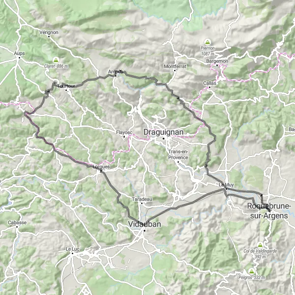
Les Trois Croix Circuit
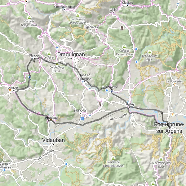
Explore the picturesque Les Trois Croix route with challenging ascents and stunning views
The Les Trois Croix Circuit offers a thrilling cycling experience, with a mix of challenging ascents and scenic landscapes. Starting near Roquebrune-sur-Argens, this 63 km road route takes you through Taradeau, Lorgues, Le Muy, and more. Enjoy the ride as you conquer the Col de l'Ange and admire the beauty of La Colle. The route ends at Vieux Moulin, leaving you with unforgettable memories of Provence-Alpes-Côte d’Azur.
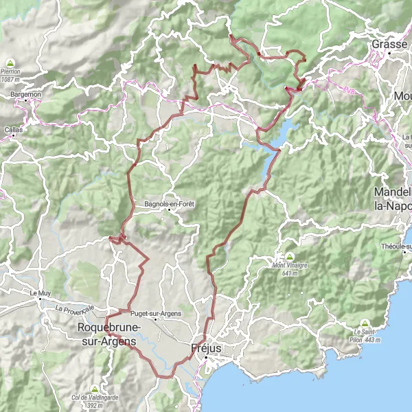
Pyöräilyreitti: Gorges du Blavet kierros
Koe jännittävä seikkailu mahtavissa rotkoissa
Tämä 63 kilometrin mittainen reitti vie sinut upeiden rotkojen läpi ja tarjoaa upeat näkymät ympäröivään luontoon. Matkalla voit ihastella esimerkiksi Collet d'Arènen huippua ja Barrage de Malpassetin patoa. Reitti tarjoaa monipuolisia maisemia ja haastetta pyöräilijöille, jotka etsivät seikkailua.
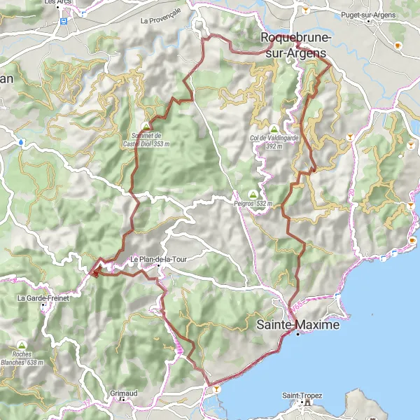
Col de Valdingarde Exploration

Embark on a cycling adventure to the scenic Col de Valdingarde and beyond
The Col de Valdingarde Exploration route is a challenging 82 km road circuit that takes you through picturesque landscapes and charming villages. Beginning near Roquebrune-sur-Argens, the route features highlights such as Le Plan-de-la-Tour, Col de Valdingarde, Vidauban, and Le Muy. Enjoy the stunning views as you conquer Colle Dure and Les Trois Croix before completing your journey back at the starting point. This route promises an unforgettable cycling experience in the heart of Provence-Alpes-Côte d’Azur.
Pyöräilyreitti: Vieux Moulin kierros

Nauti upeista maisemista ja historiallisesta tunnelmasta
Tämä 55 kilometrin mittainen reitti tarjoaa upeita maisemia ja polkuja, jotka kulkevat vanhan myllyn ohi. Matkan varrella voit nähdä Sommet Bourèten huipun sekä muita mielenkiintoisia kohteita. Reitti tarjoaa haastetta ja unohtumattomia maisemia kaikille pyöräilijöille.
Col de Valdingarde Epic Ride

Embark on an epic cycling journey to the challenging Col de Valdingarde and beyond
The Col de Valdingarde Epic Ride is a 122 km road circuit that takes you on a challenging adventure through the heart of Provence-Alpes-Côte d’Azur. Starting near Roquebrune-sur-Argens, this route features highlights such as Col du Gratteloup, Sainte-Maxime, Grimaud, and Vidauban. Challenge yourself as you conquer the steep ascents of Signal de Durand, Col de Fourche, Collet de Preires, and more before completing your journey back at Les Trois Croix. The Col de Valdingarde Epic Ride promises an unforgettable cycling experience in one of the most scenic regions of France.

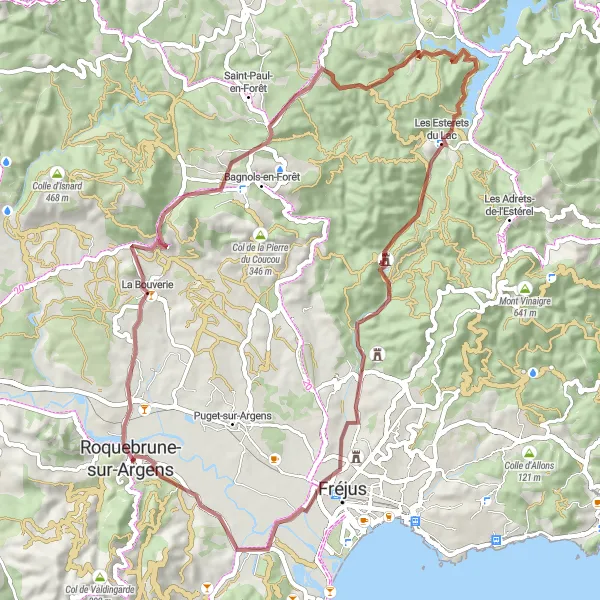
Embark on a gravel adventure to Vieux Moulin and discover the rugged beauty of the region
The Vieux Moulin Gravel Adventure is a 54 km off-road cycling route that takes you through the rugged landscapes near Roquebrune-sur-Argens. With highlights such as Sommet Bourète, Cabasse, Sainte-Maxime, and Les Trois Croix, this route offers a unique cycling experience for gravel enthusiasts. Explore the winding paths and challenging terrain as you navigate through the stunning natural scenery of Provence-Alpes-Côte d’Azur. The Vieux Moulin Gravel Adventure promises an adrenaline-filled journey through some of the most beautiful landscapes in the region.
Koe jännittävä seikkailu mahtavissa rotkoissa
Tämä 105 kilometrin mittainen reitti vie sinut upeiden rotkojen läpi ja tarjoaa upeat näkymät ympäröivään luontoon. Matkalla voit ihastella esimerkiksi Collet de Barberyn huippua ja Belvédère du Barrage de Malpasset'in näköalapaikkaa. Reitti tarjoaa monipuolisia maisemia ja haastetta pyöräilijöille, jotka etsivät seikkailua.
Pyöräilyreitti: Les Trois Croix kierros
Koe mahtavat näkymät ja historialliset kohteet
Tämä 104 kilometrin mittainen reitti tarjoaa upeita maisemia ja polkuja, jotka kulkevat Les Trois Croixin ohi. Matkan varrella voit nähdä Pey Longin ja Saint-Antonin-du-Varin huiput sekä muita mielenkiintoisia kohteita. Reitti tarjoaa haastetta ja unohtumattomia maisemia kaikille pyöräilijöille.
Pyöräilyreitti: Vieux Moulin kierros
Koe upea luonto ja historialliset kohteet
Tämä 68 kilometrin mittainen reitti tarjoaa upeita maisemia ja polkuja, jotka kulkevat vanhan myllyn ohi. Matkan varrella voit nähdä Sommet Bourèten huipun sekä muita mielenkiintoisia kohteita. Reitti tarjoaa haastetta ja unohtumattomia maisemia kaikille pyöräilijöille.
Lähellä olevat pyöräilyreitit:
Läheiset alueet: