Montélégérique Cycle Challenge
A road cycling route starting from Monteleger
Conquer the challenging Montélégérique cycling route
Map
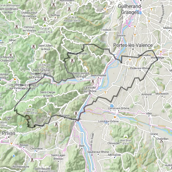
Embark on the Montélégérique Cycle Challenge, a challenging route that takes you through picturesque landscapes and includes a total ascent of 1,773 meters over 94 kilometers. This route is perfect for experienced and well-trained amateur cyclists looking for a demanding ride in the Rhône-Alpes region. With highlights including the charming town of Saint-Genys, the historic village of Rompon, and the beautiful Col de Gilhac, this route offers a mix of stunning scenery and exciting cycling challenges.
road
94 km
1773 m
Tough
Route profile
Highlights on the route
0 km
0 km
Start: Montéléger Village centerMontéléger: Tranquil cycling paradise in the Rhône-Alpes region of France.
Montéléger is a small locality in Rhône-Alpes, France. As a road and gravel cyclist, you will find plenty of scenic routes to explore in the area. The terrain is relatively flat, making it suitable for all levels of cyclists. Montéléger is surrounded by beautiful countryside, with rolling hills and vineyards. One of the famous cycling-related spots nearby is the Mont Ventoux, known for its challenging climb and stunning views at the top. Overall, Montéléger is a great destination for cycling enthusiasts looking to enjoy picturesque routes in a tranquil setting.9 km
9 km
Saint-GenysHamletStop by the charming town of Saint-Genys, known for its stunning architecture and rich history.
27 km
27 km
RomponVillageVisit the historic village of Rompon and explore its narrow streets and medieval buildings.
49 km
49 km
Saint-Vincent-de-DurfortVillageAdmire the beautiful Saint-Vincent-de-Durfort and take a break at one of its cozy cafes.
70 km
70 km
Col de Gilhac526 mMountain PassClimb the scenic Col de Gilhac and enjoy breathtaking views of the surrounding mountains.
70 km
70 km
Gilhac-et-BruzacVillageExplore Gilhac-et-Bruzac, a charming village with traditional stone houses and winding streets.
81 km
81 km
Charmes-sur-RhôneVillagePass through Charmes-sur-Rhône, a picturesque town located on the banks of the Rhône River.
94 km
94 km
MontélégerVillageFinish the route in Montéléger and reward yourself with a well-deserved meal at one of its cozy restaurants.
94 km
94 km
Finish: Montéléger Village centerMontéléger: Tranquil cycling paradise in the Rhône-Alpes region of France.
Cycling routes nearby: