Escape to the countryside and enjoy serene cycling in Hernádnémeti.
Cycling routes from Hernadnemeti
Hernádnémeti is a locality in Hungary, situated in the Észak-Magyarország region. As a road and gravel cyclist, Hernádnémeti provides a peaceful and authentic cycling experience. The town is surrounded by beautiful countryside, allowing cyclists to enjoy serene rides away from busy urban areas. Although there are no famous cycling-related spots or well-known climbs in the immediate vicinity, Hernádnémeti's relaxed atmosphere and charming scenery make it a pleasant destination for cyclists. With its tranquil setting, Hernádnémeti receives a rank of 3 as a cycling-friendly area.

Explore the charming towns of Sajópetri and Szuhogy
This cycling route takes you through the picturesque towns of Sajópetri and Szuhogy in northeastern Hungary. The route offers a mix of challenging climbs and scenic landscapes, making it suitable for experienced cyclists. With a total ascent of 585 meters and a distance of 144 kilometers, it is recommended for intermediate to advanced cyclists.

Embark on an epic road cycling adventure showcasing the highlights of Hernádnémeti and its surroundings.
With a distance of 94 km, this road cycling route provides thrilling climbs and breathtaking sights along the way. Enjoy exploring Sajópetri (distance: 11 km), a picturesque village famous for its traditional houses, Ibolyás-tető (distance: 33 km), featuring stunning views from its peak, Kisgyőr (distance: 35 km), a charming village with beautiful countryside, the Cave of Lillafüredi Tunnel (distance: 59 km), where you can explore the underground wonders, Lillafüred (distance: 59 km), a popular tourist destination surrounded by natural beauty, the Avasi kilátó (distance: 72 km), known for its panoramic city views, Zsolcai keleti halom (distance: 82 km), an archaeological site with historical significance, and Gesztely (distance: 89 km), a tranquil village with traditional architecture.
Discover the hidden gems of northeastern Hungary on this road cycling route
This road cycling route takes you through the hidden gems of northeastern Hungary, starting from Sajópetri and ending in Gesztely. With a total ascent of 549 meters and a distance of 139 kilometers, it is suitable for intermediate to advanced cyclists looking for a diverse and scenic adventure. The route combines challenging climbs with charming landscapes, offering a unique and memorable experience.
Take a captivating road cycling journey through the scenic landscapes near Hernádnémeti.
With a distance of 53 km, this road cycling route offers a blend of scenic beauty and cultural attractions near Hernádnémeti. Highlights along the route include Sajópetri (distance: 12 km), a charming village with traditional Hungarian houses, Miskolctapolca (distance: 26 km), famous for its thermal baths and unique cave bath, Camera Obscura (distance: 28 km), where you can experience an optical wonder, Zsolcai keleti halom (distance: 41 km), an archaeological site with historical significance, and Gesztely (distance: 48 km), a peaceful village with traditional architecture.

Experience the beauty of the Hungarian hills on this challenging road cycling route
This challenging road cycling route takes you through the stunning Hungarian hills, starting from Alsódobsza and ending in Tiszalúc. With a total ascent of 866 meters and a distance of 139 kilometers, it is suitable for experienced cyclists looking for a thrilling and scenic adventure. The route offers breathtaking views and exhilarating climbs, rewarding riders with a sense of achievement and unforgettable memories.
Discover the scenic beauty of Hernád river and visit the town of Sajólád
This scenic cycling route takes you along the Hernád River and through the beautiful town of Sajólád. With a total ascent of 34 meters and a distance of 93 kilometers, it is suitable for cyclists of all levels. The route offers stunning views of the river and surrounding landscapes, making it a perfect choice for nature lovers and photography enthusiasts.

Embark on a challenging road cycling journey around the beautiful surroundings of Hernádnémeti.
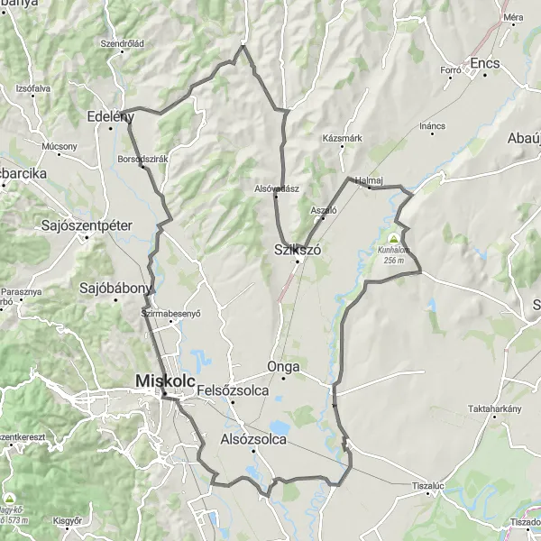
Covering a distance of 146 km, this road cycling route takes you on a scenic tour of Hernádnémeti and its neighboring attractions. Highlights along the way include Gesztely (distance: 4 km), a historic village with a charming town center, Zsolcai keleti halom (distance: 11 km), an ancient burial mound, Borsodszirák (distance: 34 km), a small tranquil village, Izsófalva (distance: 51 km), known for its quaint architecture, and the spectacular Kilátó (distance: 69 km), a lookout point offering breathtaking views of the area. Other notable stops include Galvács (distance: 73 km), where you can see traditional Hungarian houses, Esztrázs-tető (distance: 83 km), a hilltop observation deck, and Homrogd (distance: 97 km), a charming village with a rich cultural heritage.

Experience the scenic beauty and rural charm of Hernádnémeti with this gravel cycling route.
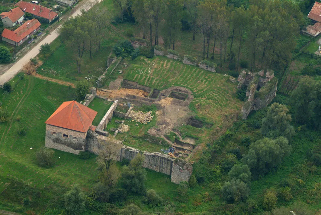
This 51 km gravel route takes you through the picturesque landscapes surrounding Hernádnémeti. Enjoy the tranquility of the countryside as you pass by Zsolcai keleti halom (distance: 11 km), an ancient burial mound, Sajópálfala (distance: 18 km), a historic village, Szikszó (distance: 33 km), known for its medieval castle ruins, and Hernádkak (distance: 48 km), with its lovely village atmosphere.
Embark on a scenic gravel adventure from Gesztely to Onga
This gravel route takes you through the picturesque Hungarian countryside from Gesztely to Onga. With a total ascent of 12 meters and a distance of 37 kilometers, it is suitable for gravel biking enthusiasts looking for a peaceful and scenic adventure. The route offers stunning views of the rolling hills and fields, making it a perfect choice for nature lovers and those who enjoy off-road cycling.
Embark on an exhilarating road cycling adventure through the hilly terrain near Hernádnémeti.
This 121 km road cycling route takes you on a thrilling journey through the undulating landscapes surrounding Hernádnémeti. Get ready to conquer challenging climbs and be rewarded with stunning vistas. Noteworthy stops along the way include Sajópetri (distance: 11 km), a picturesque village, Martinkertváros (distance: 23 km), known for its well-preserved traditional houses, Borsodszirák (distance: 46 km), a peaceful village surrounded by nature, Tomor (distance: 65 km), famous for its panoramic views, Aszaló (distance: 86 km), with its charming traditional houses, and Szentistvánbaksa (distance: 97 km), a small village showcasing the rural charm of Hungary. The route also passes by the historical landmarks of Kunhalom (distance: 99 km) and Alsódobsza (distance: 107 km).
Cycling routes nearby:


Nearby regions: