Gravel Route around Fareins
Cyklotrasa gravel začínajúca od Fareins
50 km gravel route with 316 meters ascent
Mapa
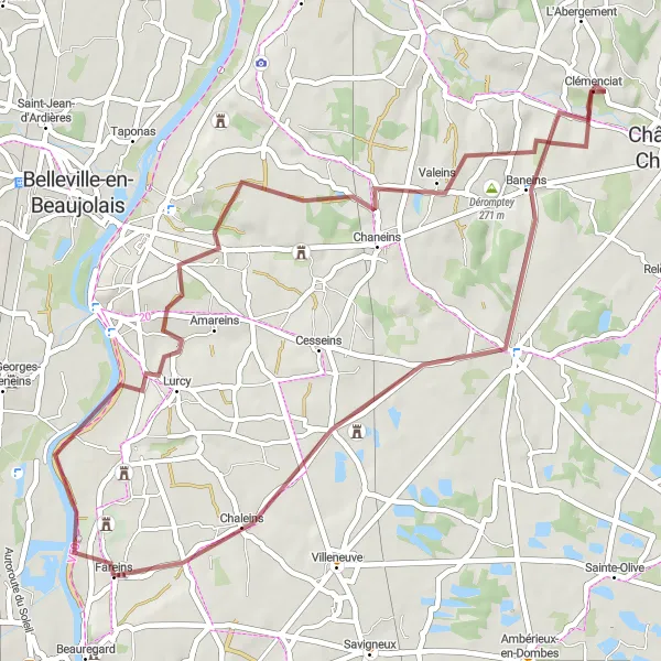
Explore the charming countryside near Fareins on this 50 km gravel route, enjoying picturesque views and peaceful surroundings. With a manageable ascent of 316 meters, the route offers a pleasant challenge for intermediate cyclists. Discover hidden gems like Lurcy and Montceaux along the way, adding a touch of local flavor to your adventure.
gravel
50 km
316 m
Ťažký
Profil trasy
Zaujímavosti na trase
0 km
0 km
Štart: Fareins Village centerFareins: Malebná lokalita pre oddychové jazdy.
Fareins je malebná lokalita nachádzajúca sa v regióne Rhône-Alpes vo Francúzsku. Pre cyklistov ponúka pomerne rovinaté cesty a príjemné prostredie na oddychové jazdy. Okolie je vhodné na pokojnú cyklistiku a objavovanie miestnych pamiatok. Aj keď v blízkosti nie sú žiadne známe cyklistické trasy, môžete si tu užiť relaxačné cyklovyjazdenia.8 km
8 km
LurcyDedinaRide through the quaint village of Lurcy, known for its beautiful architecture and friendly locals.
13 km
13 km
MontceauxDedinaStop by the historic town of Montceaux, where you can relax and enjoy the serene atmosphere.
23 km
23 km
Déromptey271 mVrcholExplore the scenic area of Déromptey, surrounded by lush greenery and tranquil landscapes.
33 km
33 km
BaneinsDedinaPass through the charming village of Baneins, where you can take a break and admire the traditional French architecture.
46 km
46 km
ChaleinsDedinaCycle through the idyllic countryside of Chaleins, with its rolling hills and stunning views.
50 km
50 km
Cieľ: Fareins Village centerFareins: Malebná lokalita pre oddychové jazdy.
Cyklotrasy od Fareins:
Jazda na štrkových cestách okolo Fareins Objavte kúzlo okolia Fareins Cyklistický výlet s panoramatickým pohľadom Z Fareins na dlhý výlet s náročným stúpaním Výlet so zaujímavými histórickými miestami Cyklotrasa pre horské bicykle v okolí Fareins (Rhône-Alpes, Francúzsko) Náročná cyklotrasa cez okolie Fareins Okruh s výstupom do Messimy-sur-Saône Road Route near Fareins Gravel Route around Fareins