![Cover image](https://images.tarmacs.app/cycling-routes/covers/switzerland/ostschweiz/pontresina-4.webp)
Horská cyklistika v údolí Engadin
Cyklistické trasy kolem Pontresina
Pontresina je malebné horské městečko ležící v údolí Engadin ve švýcarských Alpách. Cyklisté si zde užijí nádherné výhledy a možnost projet se kolem ledovců a jezer. V blízkosti se nachází slavná horská průsmyčka jako Bernina Pass nebo Julier Pass. Pontresina je skvělým výchozím bodem pro horské cyklisty.
![Miniaturní mapa "Gravel Cyklotrasa Cascada da Bernina - Pontresina" inspirace pro cyklisty v oblasti Ostschweiz, Switzerland. Vytvořeno pomocí plánovače tras Tarmacs.app](https://images.tarmacs.app/cycling-routes/routemaps/600/switzerland/ostschweiz/pontresina/gravel/281101.webp)
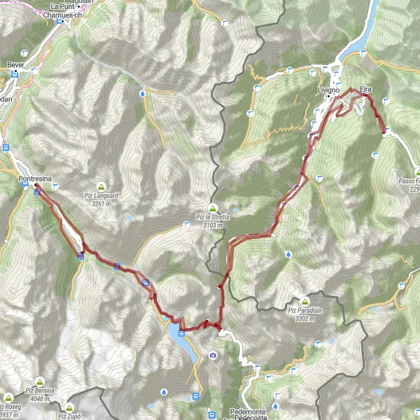
Náročná cyklotrasa přes Berninapass a Livigno s nádhernými výhledy na horské scenérie
Cyklotrasa o délce 88km vede přes několik pamětihodností včetně Cascada da Bernina, Berninapass a Monte Crapene`. S převýšením 2463m poskytuje náročný výlet pro zkušené gravel bikery s nezapomenutelnými výhledy a atmosférou dolomitských Alp.
![Miniaturní mapa "Road výlet kolem Engadinu" inspirace pro cyklisty v oblasti Ostschweiz, Switzerland. Vytvořeno pomocí plánovače tras Tarmacs.app](https://images.tarmacs.app/cycling-routes/routemaps/600/switzerland/ostschweiz/pontresina/road/281121.webp)
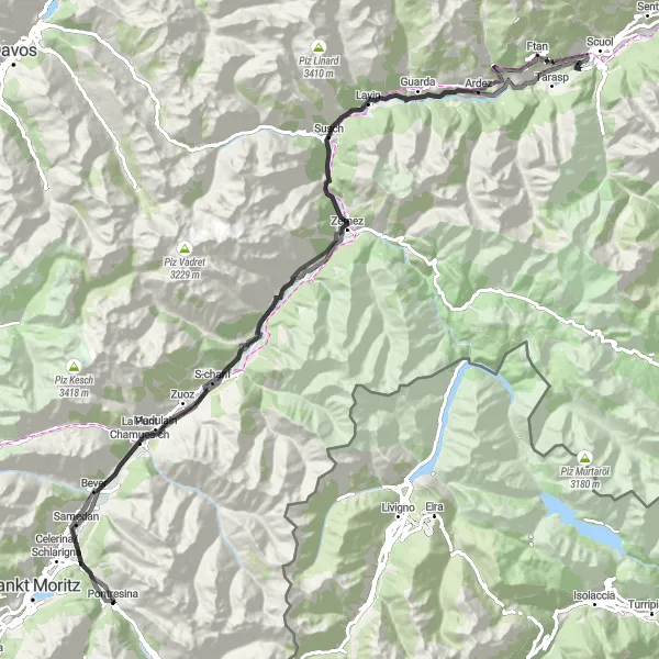
Malebná cesta s výhledy na Castle Planta-Wildenberg a Ftan
Jízda po 122km dlouhé trase kolem Engadinu nabízí krásné výhledy na horské scenérie a malebné vesničky. Zastavte se na hrade Planta-Wildenberg nebo si užijte klidné prostředí ve Ftanu. Trasa je vhodná pro cyklisty, kteří si chtějí vychutnat krásu švýcarské krajiny s celkovým převýšením 2050m.
![Miniaturní mapa "Okruh kolem Pontresiny - Silvaplana" inspirace pro cyklisty v oblasti Ostschweiz, Switzerland. Vytvořeno pomocí plánovače tras Tarmacs.app](https://images.tarmacs.app/cycling-routes/routemaps/600/switzerland/ostschweiz/pontresina/road/281114.webp)
Báječná cyklistická trasa s impozantními výhledy
Tato 108km dlouhá cesta nabízí nádherné scenérie od jezera Silvaplana až po horské průsmyky Albulapass a Berninapass. Navštívíte malebná městečka jako Bergün/Bravuogn a La Punt Chamues-ch.
![Miniaturní mapa "Gravel Cyklotrasa Röntgenplatz - Pontresina" inspirace pro cyklisty v oblasti Ostschweiz, Switzerland. Vytvořeno pomocí plánovače tras Tarmacs.app](https://images.tarmacs.app/cycling-routes/routemaps/600/switzerland/ostschweiz/pontresina/gravel/281124.webp)
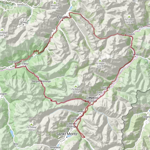
Malebná cyklotrasa s výhledy na údolí Albula, historické obce a horskou krajinu
Tato 147km dlouhá cyklotrasa nabízí nádherné výhledy na Röntgenplatz, Albulapass, Wiesner Viadukt a mnoho dalších perel regionu. Celkové převýšení 4223m zajistí neopakovatelný zážitek pro milovníky gravel cyklistiky.
![Miniaturní mapa "Gravel Route through Engadin Valley" inspirace pro cyklisty v oblasti Ostschweiz, Switzerland. Vytvořeno pomocí plánovače tras Tarmacs.app](https://images.tarmacs.app/cycling-routes/routemaps/600/switzerland/ostschweiz/pontresina/gravel/281084.webp)
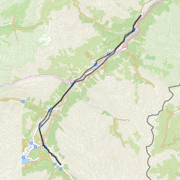
Explore the stunning Engadin Valley on this gravel route full of scenic views and charming villages.
Cycle through picturesque landscapes, passing by the quaint village of La Punt Chamues-ch and the historic town of Samedan. Enjoy the challenge of a 421m ascent over 38km of gravel roads, with rewarding views of the surrounding mountains. Experience the beauty of the Swiss Alps on this distinctive cycling adventure.
![Miniaturní mapa "Silvaplana - La Punt Chamues-ch Loop" inspirace pro cyklisty v oblasti Ostschweiz, Switzerland. Vytvořeno pomocí plánovače tras Tarmacs.app](https://images.tarmacs.app/cycling-routes/routemaps/600/switzerland/ostschweiz/pontresina/road/281123.webp)
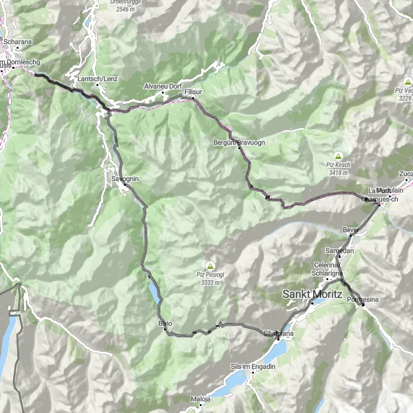
Exciting road cycling route with challenging climbs and scenic landscapes in the Swiss Alps.
Embark on a thrilling journey from Silvaplana to La Punt Chamues-ch, passing through iconic landmarks like Piz Polaschin and Albulapass. Enjoy the sweeping views of Motta Vallac and Bergün/Bravuogn along the way. Discover the hidden gem of Tgarnet and the historic charm of Tinizong. This route offers a mix of challenging ascents and thrilling descents, making it ideal for cyclists seeking an unforgettable adventure in Ostschweiz.
![Miniaturní mapa "Cyklotrasa Bever - Pontresina" inspirace pro cyklisty v oblasti Ostschweiz, Switzerland. Vytvořeno pomocí plánovače tras Tarmacs.app](https://images.tarmacs.app/cycling-routes/routemaps/600/switzerland/ostschweiz/pontresina/road/281097.webp)
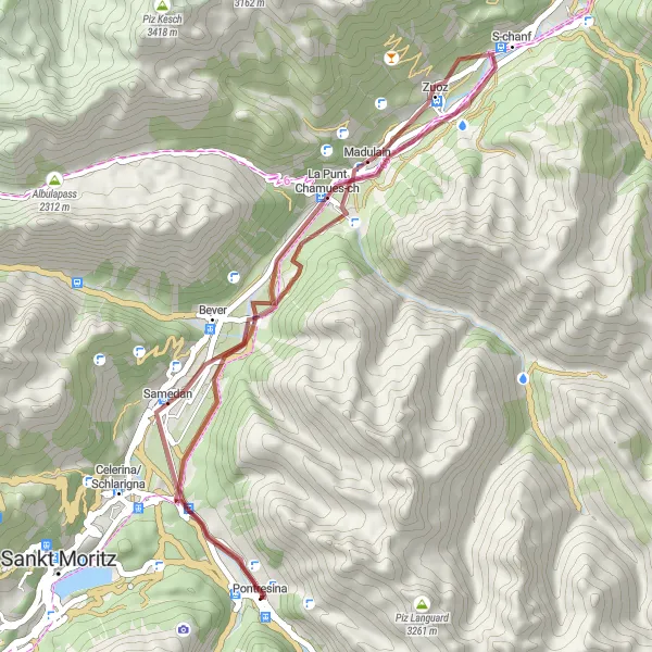
Poutavá cesta plná malebných vesniček a přírodních krás
Tato 51km dlouhá trasa vás provede malebnými vesnicemi jako Bever a Madulain až do Pontresiny. Po cestě můžete obdivovat úchvatné horské scenérie a historickou architekturu.
![Miniaturní mapa "Silvaplana - Bever Circuit" inspirace pro cyklisty v oblasti Ostschweiz, Switzerland. Vytvořeno pomocí plánovače tras Tarmacs.app](https://images.tarmacs.app/cycling-routes/routemaps/600/switzerland/ostschweiz/pontresina/road/281122.webp)
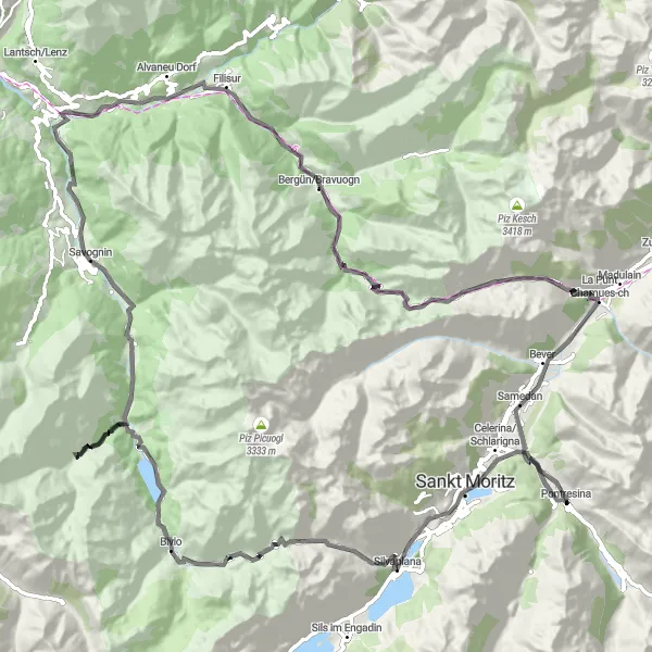
Scenic road cycling route with challenging ascents and stunning views of the Swiss Alps.
Explore the picturesque villages of Silvaplana, Tinizong, and Bergün/Bravuogn as you conquer the Albulapass. Enjoy the panoramic vistas of Motta Vallac and Plam Pedra Purtgera along the way. Stop at historic landmarks like Mulegns and Konzertplatz Tais for a cultural experience. This route offers a mix of challenging climbs and exhilarating descents, perfect for avid cyclists looking for a memorable ride in Ostschweiz.
![Miniaturní mapa "Gravel Cyklotrasa Röntgenplatz - Pontresina" inspirace pro cyklisty v oblasti Ostschweiz, Switzerland. Vytvořeno pomocí plánovače tras Tarmacs.app](https://images.tarmacs.app/cycling-routes/routemaps/600/switzerland/ostschweiz/pontresina/gravel/281100.webp)
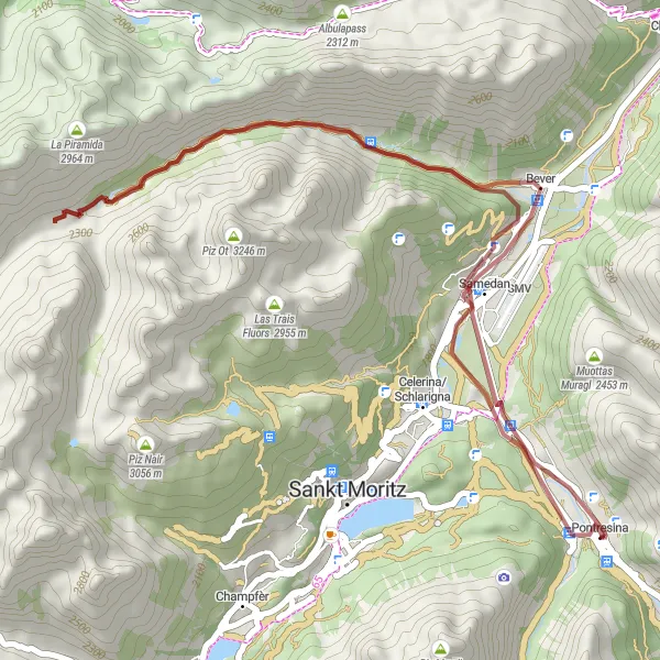
Malebná trasa s výhledy na údolí a horské vrcholy
40km dlouhá cyklotrasa nabízí zajímavé výhledy na Röntgenplatz, Samedan, Fuorcla Crap Alv a další pamětihodnosti kraje. S převýšením 882m je vhodná pro rekreační cyklisty i rodiny s dětmi.
![Miniaturní mapa "Gravelová cesta Berninapass - Pontresina" inspirace pro cyklisty v oblasti Ostschweiz, Switzerland. Vytvořeno pomocí plánovače tras Tarmacs.app](https://images.tarmacs.app/cycling-routes/routemaps/600/switzerland/ostschweiz/pontresina/gravel/281115.webp)
Náročná trasa s úchvatnými výhledy na Alpy
Tato 71km dlouhá cesta vede přes spektakulární průsmyk Berninapass až do Pontresiny. Po cestě můžete obdivovat ledovcová jezera a panoramatické výhledy.
Cyklotrasy v okolí:
![Obrázek Nauders](https://images.tarmacs.app/cycling-routes/covers/austria/tirol/nauders-2.webp)
![Obrázek Tschagguns](https://images.tarmacs.app/cycling-routes/covers/austria/vorarlberg/tschagguns-5.webp)
![Obrázek Schruns](https://images.tarmacs.app/cycling-routes/covers/austria/vorarlberg/schruns-4.webp)
![Obrázek Bartholomäberg](https://images.tarmacs.app/cycling-routes/covers/austria/vorarlberg/bartholomaeberg-5.webp)
![Obrázek Vandans](https://images.tarmacs.app/cycling-routes/covers/austria/vorarlberg/vandans-3.webp)
![Obrázek Pfunds](https://images.tarmacs.app/cycling-routes/covers/austria/tirol/pfunds-5.webp)
![Obrázek Bürs](https://images.tarmacs.app/cycling-routes/covers/austria/vorarlberg/buers-5.webp)
![Obrázek Kappl](https://images.tarmacs.app/cycling-routes/covers/austria/tirol/kappl-5.webp)
![Obrázek Bludenz](https://images.tarmacs.app/cycling-routes/covers/austria/vorarlberg/bludenz-5.webp)
Okolní oblasti:
![Obrázek Kärnten](https://images.tarmacs.app/cycling-routes/covers/austria/karnten/sankt-veit-an-der-glan-1.webp)
![Obrázek Steiermark](https://images.tarmacs.app/cycling-routes/covers/austria/steiermark/pichling-bei-koeflach-3.webp)
![Obrázek Oberösterreich](https://images.tarmacs.app/cycling-routes/covers/austria/oberosterreich/traun-4.webp)
![Obrázek Salzburg](https://images.tarmacs.app/cycling-routes/covers/austria/salzburg/neualm-4.webp)
![Obrázek Tirol](https://images.tarmacs.app/cycling-routes/covers/austria/tirol/amras-5.webp)
![Obrázek Vorarlberg](https://images.tarmacs.app/cycling-routes/covers/austria/vorarlberg/tschagguns-4.webp)
![Obrázek Zürich](https://images.tarmacs.app/cycling-routes/covers/switzerland/zurich/erlenbach-1.webp)
![Obrázek Ticino](https://images.tarmacs.app/cycling-routes/covers/switzerland/ticino/magadino-4.webp)
![Obrázek Tübingen](https://images.tarmacs.app/cycling-routes/covers/germany/tubingen/unterhausen-3.webp)
![Obrázek Schwaben](https://images.tarmacs.app/cycling-routes/covers/germany/schwaben/nonnenhorn-3.webp)
![Obrázek Lombardia](https://images.tarmacs.app/cycling-routes/covers/italy/lombardia/albavilla-1.webp)
![Obrázek Provincia Autonoma di Bolzano/Bozen](https://images.tarmacs.app/cycling-routes/covers/italy/provincia-autonoma-di-bolzano-bozen/lana-3.webp)
![Obrázek Liechtenstein](https://images.tarmacs.app/cycling-routes/covers/liechtenstein/liechtenstein/eschen-3.webp)