Epische Gravel-Tour durch Střední Morava
Eine gravel-Radroute, die von Ostrozska Lhota aus startet.
Erlebe auf dieser 87 km langen Gravel-Tour das Abenteuer in Střední Morava.
Karte
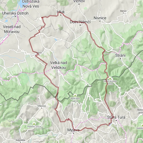
Diese Route führt dich durch beeindruckende Landschaften und malerische Dörfer wie Dolní Němčí, Veľká Javorina und Blatnice pod Svatým Antonínkem. Mit einem Anstieg von 1536 m ist dies eine anspruchsvolle Tour für erfahrene Radfahrer, die die Herausforderung suchen und die unberührte Natur der Region erkunden möchten.
gravel
87 km
1536 m
Schwierig
Streckenprofil
Höhepunkte auf der Strecke
0 km
0 km
Start: Ostrožská Lhota Village centerOstrožská Lhota: Interessante Strecken und landschaftliche Schönheit
Ostrožská Lhota in der Region Střední Morava bietet Fahrradfahrern einige interessante Strecken und ruhige Straßen zum Erkunden. Die Umgebung ist landschaftlich reizvoll und eignet sich gut für Touren. Es gibt keine berühmten Radstrecken oder Anstiege in der Nähe, aber die friedliche Atmosphäre macht diese Gegend ideal zum Radfahren.10 km
10 km
Dolní NěmčíStadtErkunde das idyllische Dorf Dolní Němčí während deiner Fahrt.
27 km
27 km
Veľká Javorina970 mAussichtspunktBesuche den beeindruckenden Veľká Javorina während deiner Tour.
59 km
59 km
Ostrý vrch601 mGipfelGenieße die Aussicht vom Ostrý vrch während deiner Fahrt.
67 km
67 km
KuželovDorfErkunde die malerischen Landschaften rund um Kuželov.
72 km
72 km
Hájová354 mGipfelBesuche das charmante Hájová auf deinem Weg.
82 km
82 km
Blatnice pod Svatým AntonínkemDorfErkunde die grünen Wälder rund um Blatnice pod Svatým Antonínkem.
84 km
84 km
Antonínský kopec350 mGipfelBesuche den imposanten Antonínský kopec während deiner Fahrt.
87 km
87 km
Ziel: Ostrožská Lhota Village centerOstrožská Lhota: Interessante Strecken und landschaftliche Schönheit
Radwege von Ostrozska Lhota:
Epische Gravel-Tour durch Střední Morava Abenteuerliche Gravel-Tour durch Střední Morava Veletiny und Dolní Němčí Rundweg Blatnice pod Svatým Antonínkem und Roháč Radtour Antonínský kopec und Kněždub Schotterweg Bukovanský mlýn und Buchlovice Rundweg Road-Tour durch die malerische Landschaft Road-Tour durch Střední Morava Uherský Ostroh und Cimburk Gravelroute Gravel-Tour um Střední Morava
In der Nähe befinden sich Fahrradrouten: