![Cover image](https://images.tarmacs.app/cycling-routes/covers/italy/toscana/antella-5.webp)
Malerisches Örtchen mit herausfordernden Anstiegen
Fahrradrouten rund um Antella
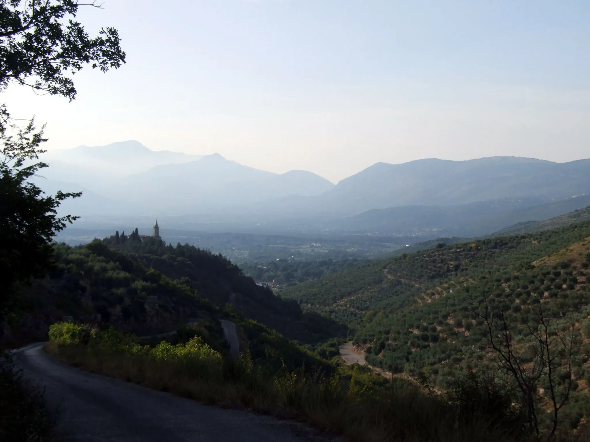
Antella ist ein malerisches Örtchen mit perfekten Bedingungen für Radfahrer. Die hügelige Landschaft bietet herausfordernde Anstiege und schöne Ausblicke, die Radfahrer begeistern werden.
![Karten-Miniaturansicht der Radinspiration "Aufregende Schotterrunde um Antella" in Toscana, Italy. Erstellt vom Tarmacs.app-Routenplaner für Radtouren](https://images.tarmacs.app/cycling-routes/routemaps/600/italy/toscana/antella/gravel/287799.webp)
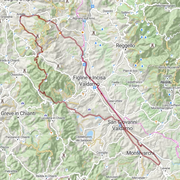
Entdecken Sie die malerische Landschaft um Antella auf dieser 90 km langen Schotterroute.
Die Tour bietet atemberaubende Panoramen und führt Sie durch idyllische Dörfer wie Levanella und San Giovanni Valdarno. Der Anstieg von 1449 m sorgt für eine sportliche Herausforderung, belohnt aber mit unvergesslichen Ausblicken.
Kurvenreiche Straßentour um Antella
![Karten-Miniaturansicht der Radinspiration "Kurvenreiche Straßentour um Antella" in Toscana, Italy. Erstellt vom Tarmacs.app-Routenplaner für Radtouren](https://images.tarmacs.app/cycling-routes/routemaps/600/italy/toscana/antella/road/287737.webp)
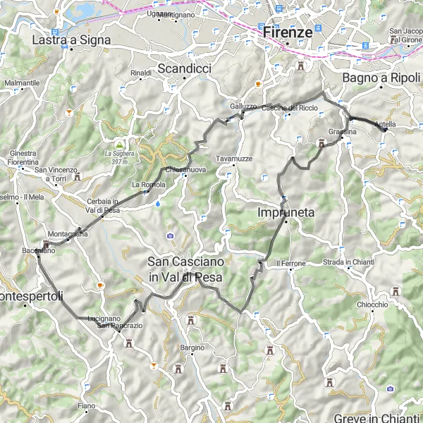
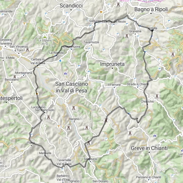
Erkunden Sie die Umgebung von Antella auf dieser 66 km langen Straßenroute durch malerische Dörfer.
Die Tour führt Sie zu romantischen Orten wie Monte Cuccioli und Poggio delle Monache. Mit einem Anstieg von 1157 m bietet die Strecke eine abwechslungsreiche Fahrt durch die toskanische Landschaft.
![Karten-Miniaturansicht der Radinspiration "Kulturelle Vielfalt: Antella - Ponte a Niccheri Strecke" in Toscana, Italy. Erstellt vom Tarmacs.app-Routenplaner für Radtouren](https://images.tarmacs.app/cycling-routes/routemaps/600/italy/toscana/antella/gravel/287621.webp)
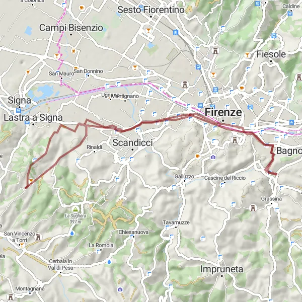
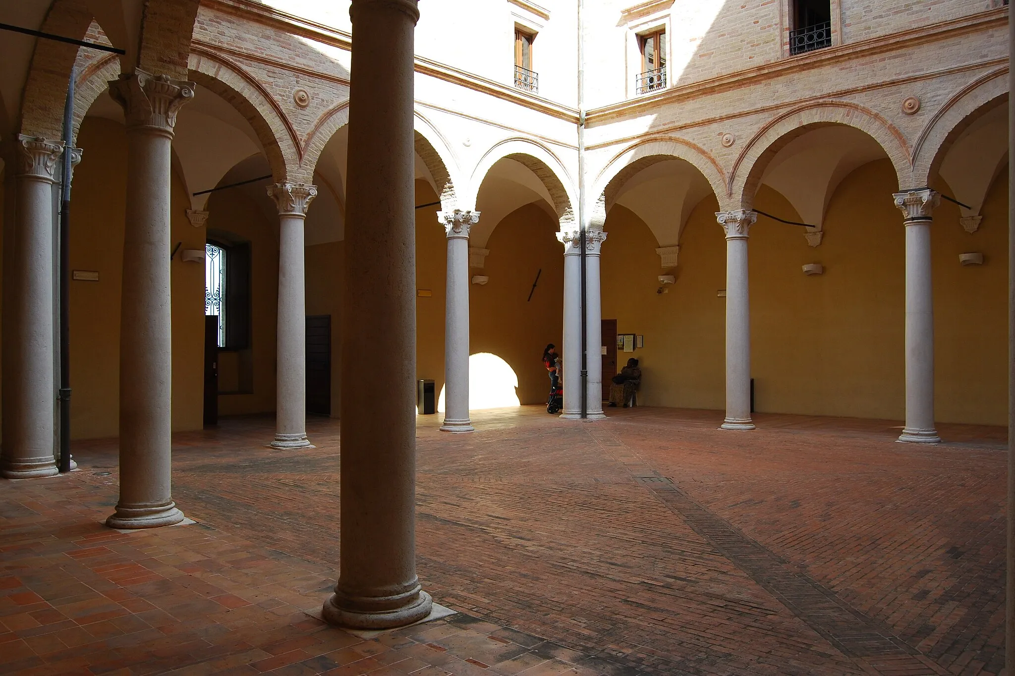
Erfahre kulturelle Vielfalt auf dieser abwechslungsreichen Schotterroute
Diese 46 km lange Schotterstrecke führt von Antella nach Ponte a Niccheri durch malerische Dörfer und historische Plätze. Zu den Highlights gehören der Ponte Vecchio, das Poggio Mulettino und das Belvedere Franco Zeffirelli. Eine Tour, die Geschichte und Natur miteinander verbindet.
![Karten-Miniaturansicht der Radinspiration "Kultur pur: Antella - Baroncelli Tour" in Toscana, Italy. Erstellt vom Tarmacs.app-Routenplaner für Radtouren](https://images.tarmacs.app/cycling-routes/routemaps/600/italy/toscana/antella/gravel/287598.webp)
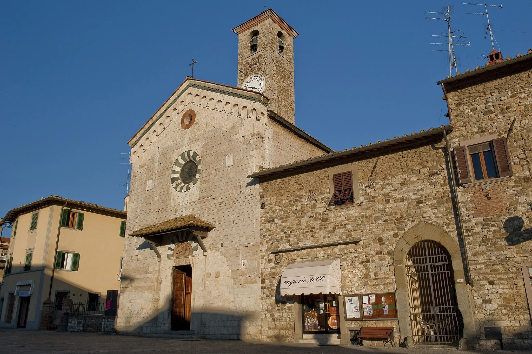
Erkunde die historischen Sehenswürdigkeiten entlang der Strecke
Diese 26 km lange Schotterroute führt von Antella zum Baroncelli-Dorf. Sehenswürdigkeiten wie das Belvedere Franco Zeffirelli und Bagno a Ripoli laden zu kulturellen Erkundungen ein. Die Tour bietet Geschichte, Natur und unvergessliche Eindrücke.
![Karten-Miniaturansicht der Radinspiration "Herausforderung pur: Antella - Passo della Consuma Rundtour" in Toscana, Italy. Erstellt vom Tarmacs.app-Routenplaner für Radtouren](https://images.tarmacs.app/cycling-routes/routemaps/600/italy/toscana/antella/road/287619.webp)
Stelle dich der sportlichen Herausforderung auf dieser asphaltierten Strecke
Diese 78 km lange Straßenroute bietet sportliche Herausforderungen und schöne Ausblicke. Highlights sind das Belvedere Franco Zeffirelli, Pian di San Bartolo und der Poggio Capanne. Ein Muss für alle Radsportbegeisterten.
![Karten-Miniaturansicht der Radinspiration "Aufregende Schottertour rund um Antella" in Toscana, Italy. Erstellt vom Tarmacs.app-Routenplaner für Radtouren](https://images.tarmacs.app/cycling-routes/routemaps/600/italy/toscana/antella/gravel/287627.webp)
Erkunden Sie auf dieser 64 km langen Schotterroute die Naturschönheiten der Region.
Die Tour führt Sie durch atemberaubende Landschaften zu Highlights wie Parco del Ventaglio und Poggio Capanne. Mit einem Anstieg von 1534 m bietet die Route ein unvergessliches Erlebnis für Abenteuerlustige.
Rundtour durch malerische Landschaft
![Karten-Miniaturansicht der Radinspiration "Rundtour durch malerische Landschaft" in Toscana, Italy. Erstellt vom Tarmacs.app-Routenplaner für Radtouren](https://images.tarmacs.app/cycling-routes/routemaps/600/italy/toscana/antella/road/287642.webp)
Entdecken Sie auf dieser 76 km langen Straßenroute die Schönheit der toskanischen Landschaft.
Die Strecke führt Sie zu bezaubernden Orten wie Chiocchio, Lucardo und Poggio al Torrino. Mit einem Anstieg von 1470 m bietet die Tour eine perfekte Mischung aus Kultur und Natur.
![Karten-Miniaturansicht der Radinspiration "Panoramische Straßenrunde von Antella" in Toscana, Italy. Erstellt vom Tarmacs.app-Routenplaner für Radtouren](https://images.tarmacs.app/cycling-routes/routemaps/600/italy/toscana/antella/road/287774.webp)
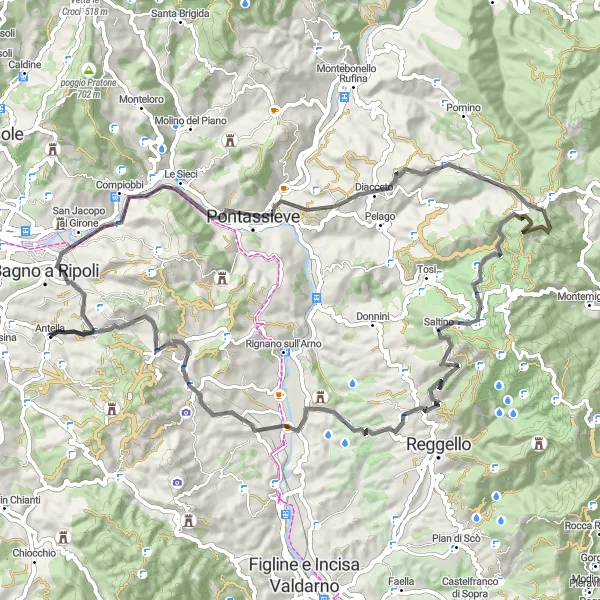
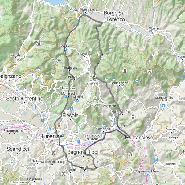
Erleben Sie bei dieser 79 km langen Radtour die atemberaubende Schönheit der Toskana.
Diese Route bietet anspruchsvolle Anstiege und atemberaubende Ausblicke auf die malerische Landschaft der Toskana. Von den Dörfern Baroncelli und Vallina bis zum Passo della Consuma und dem Il Paradisino erwarten Sie viele Highlights entlang des Weges. Besuchen Sie die historische Stadt San Francesco und genießen Sie die Ruhe in den idyllischen Orten Troghi und Poggio Le Serre. Die Fahrt endet in Antella, wo Sie eine wohlverdiente Pause machen können.
![Karten-Miniaturansicht der Radinspiration "Entdecke die Natur: Antella - Monte Giovi Rundfahrt" in Toscana, Italy. Erstellt vom Tarmacs.app-Routenplaner für Radtouren](https://images.tarmacs.app/cycling-routes/routemaps/600/italy/toscana/antella/gravel/287632.webp)
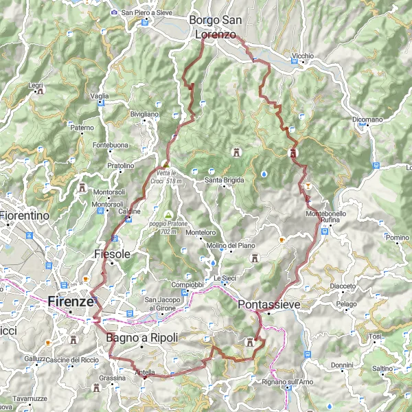
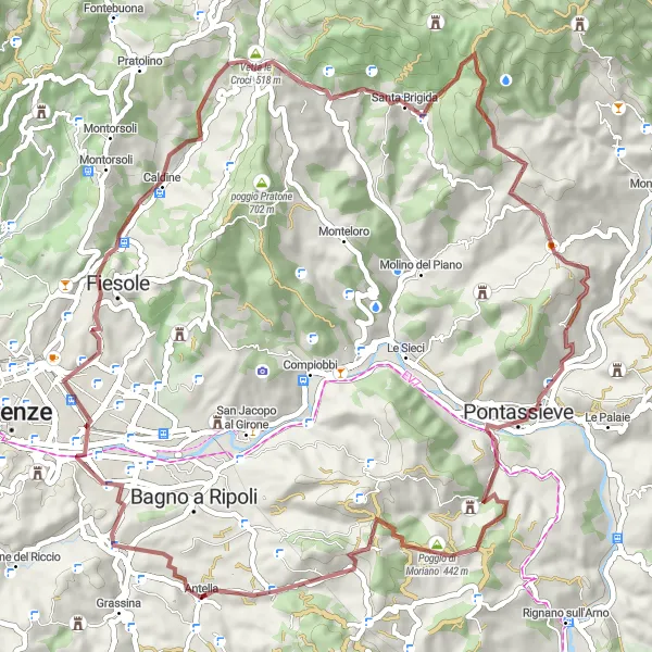
Erlebe eine abwechslungsreiche Tour durch die toskanische Landschaft
Diese 88 km lange Schotterstrecke bietet eine atemberaubende Aussicht von Ponte a Ema bis zum Monte Giovi. Unterwegs passierst du den Parco del Ventaglio und den Poggio Leccia. Die Route ist anspruchsvoll, aber belohnt mit unvergesslichen Eindrücken.
![Karten-Miniaturansicht der Radinspiration "Road-Tour mit pittoresken Stopps" in Toscana, Italy. Erstellt vom Tarmacs.app-Routenplaner für Radtouren](https://images.tarmacs.app/cycling-routes/routemaps/600/italy/toscana/antella/road/287803.webp)
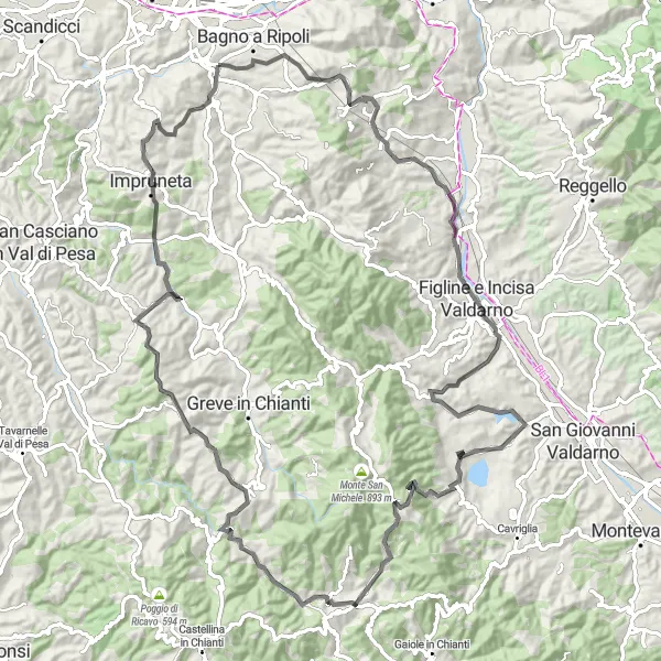
Entdecken Sie auf dieser 104 km langen Straßenroute historische Schätze entlang des Weges.
Die Strecke führt Sie vorbei an Ponte a Ema, Figline e Incisa Valdarno und Castello di Gabbiano. Mit einem Anstieg von 1952 m ist diese Tour eine echte Herausforderung für Radsportbegeisterte.
In der Nähe befinden sich Fahrradrouten:
![Bild von Ponte a Ema](https://images.tarmacs.app/cycling-routes/covers/italy/toscana/ponte-a-ema-5.webp)
![Bild von Bagno a Ripoli](https://images.tarmacs.app/cycling-routes/covers/italy/toscana/bagno-a-ripoli-4.webp)
![Bild von San Jacopo al Girone](https://images.tarmacs.app/cycling-routes/covers/italy/toscana/san-jacopo-al-girone-5.webp)
![Bild von Compiobbi](https://images.tarmacs.app/cycling-routes/covers/italy/toscana/compiobbi-5.webp)
![Bild von Impruneta](https://images.tarmacs.app/cycling-routes/covers/italy/toscana/impruneta-4.webp)
![Bild von Strada in Chianti](https://images.tarmacs.app/cycling-routes/covers/italy/toscana/strada-in-chianti-5.webp)
![Bild von Florenz](https://images.tarmacs.app/cycling-routes/covers/italy/toscana/florence-5.webp)
![Bild von Tavarnuzze](https://images.tarmacs.app/cycling-routes/covers/italy/toscana/tavarnuzze-5.webp)
![Bild von Fiesole](https://images.tarmacs.app/cycling-routes/covers/italy/toscana/fiesole-2.webp)
Benachbarte Regionen:
![Bild von Corse](https://images.tarmacs.app/cycling-routes/covers/france/corse/saint-florent-1.webp)
![Bild von Piemont](https://images.tarmacs.app/cycling-routes/covers/italy/piemonte/boves-3.webp)
![Bild von Ligurien](https://images.tarmacs.app/cycling-routes/covers/italy/liguria/casarza-ligure-1.webp)
![Bild von Lombardei](https://images.tarmacs.app/cycling-routes/covers/italy/lombardia/arcene-5.webp)
![Bild von Abruzzo](https://images.tarmacs.app/cycling-routes/covers/italy/abruzzo/balsorano-5.webp)
![Bild von Autonome Provinz Trient](https://images.tarmacs.app/cycling-routes/covers/italy/provincia-autonoma-di-trento/borgo-valsugana-3.webp)
![Bild von Venetien](https://images.tarmacs.app/cycling-routes/covers/italy/veneto/volpago-del-montello-4.webp)
![Bild von Emilia-Romagna](https://images.tarmacs.app/cycling-routes/covers/italy/emilia-romagna/solignano-nuovo-5.webp)
![Bild von Umbria](https://images.tarmacs.app/cycling-routes/covers/italy/umbria/bastardo-5.webp)
![Bild von Marken](https://images.tarmacs.app/cycling-routes/covers/italy/marche/monte-san-giusto-3.webp)
![Bild von Lazio](https://images.tarmacs.app/cycling-routes/covers/italy/lazio/amaseno-4.webp)