
Aravis Mountain Challenge
Pyöräilyreitti gravel alkaen Faverges
Conquer the rugged terrain of the Aravis mountains on this challenging gravel cycling route
Kartta
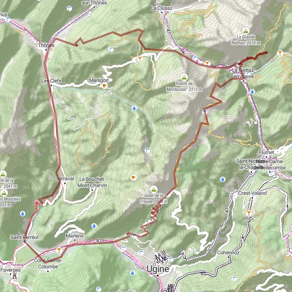
The Aravis Mountain Challenge is an 80km gravel cycling route with 3163m of ascent, taking you through rugged landscapes to hidden gems like Abri de la Taverne and Tête de l'Aulp. Experience the thrill of conquering the Col des Aravis and admire the serene beauty of Cons-Sainte-Colombe along the way.
gravel
80 km
3163 m
Raaka
Reitin profiili
Reitin kohokohdat
0 km
0 km
Aloitus: Saint-Ferréol Village centerFaverges: Hyvät pyöräilymahdollisuudet maantiellä ja maastossa
Faverges on kaupunki Ranskassa Rhône-Alpesin alueella. Kaupungissa on hyvät pyöräilymahdollisuudet sekä maantiellä että maastossa. Lähellä sijaitsee tunnettuja pyöräreittejä ja haastavia nousuja.10 km
10 km
Col des Marais833 mVuoristosolaCol des Marais offers a challenging ascent with stunning views over the rugged terrain of the Aravis mountains.
14 km
14 km
Les ClefsKyläLes Clefs is a tranquil hamlet surrounded by picturesque mountain scenery and lush green meadows.
23 km
23 km
Abri de la TaverneSuojaAbri de la Taverne is a hidden cave shelter with a rich history waiting to be discovered.
33 km
33 km
Col des Aravis1487 mVuoristosolaCol des Aravis is a challenging mountain pass with breathtaking views of the surrounding peaks.
44 km
44 km
La Giettaz-en-AravisKyläLa Giettaz-en-Aravis offers a peaceful retreat amidst the rugged beauty of the Aravis mountains.
56 km
56 km
Tête de l'Aulp2129 mHuippuTête de l'Aulp is a scenic peak offering panoramic views over the surrounding valleys and mountains.
78 km
78 km
Cons-Sainte-ColombeKyläCons-Sainte-Colombe welcomes you with its peaceful atmosphere and stunning views over the valley.
80 km
80 km
Maali: Saint-Ferréol Village centerFaverges: Hyvät pyöräilymahdollisuudet maantiellä ja maastossa