
Rhône/Rhin Watershed Gravel Ride
Pyöräilyreitti gravel alkaen Lausanne
Discover the divide between the Rhône and Rhine watersheds on this gravel cycling adventure.
Kartta
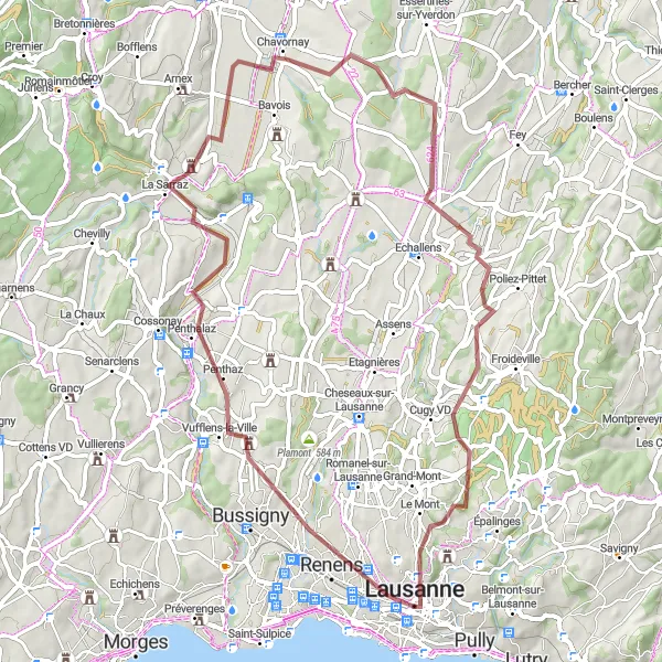
Experience 822m of ascent over 61km of diverse landscapes, passing through Prilly, La Sarraz, Chavornay, Étang du Buron, Bottens, Le Mont, and the Sauvabelin tower.
gravel
61 km
822 m
Kova
Reitin profiili
Reitin kohokohdat
0 km
0 km
Aloitus: Lausanne City centerLausanne: Upeat maisemat ja haastavat nousut
Lausanne sijaitsee upealla paikalla Genevenjärven rannalla tarjoten upeat maisemat pyöräilijöille. Kaupungissa on monia pyöräilyreittejä ja tunnettuja nousuja, kuten Chalet-à-Gobet ja Col du Mollendruz, jotka houkuttelevat kuntoaan kohentavia pyöräilijöitä. Lausanne on mahtava paikka niin maantie- kuin maastopyöräilyyn, ja tarjoaa vaihtelevia reittejä eri kuntoisille pyöräilijöille.0 km
0 km
Esplanade de MontbenonNäköalapaikkaBegin your ride at the scenic Esplanade de Montbenon in Lausanne.
2 km
2 km
PrillyKaupunkiRide through the charming village of Prilly with its traditional Swiss architecture.
22 km
22 km
Ligne de partage des eaux Rhône/Rhin485 mVuoristosolaCross the watershed between the Rhône and Rhine rivers at the Ligne de partage des eaux.
22 km
22 km
La SarrazKyläExplore the historic town of La Sarraz with its medieval charm.
30 km
30 km
ChavornayKyläPass through the picturesque town of Chavornay on your journey.
35 km
35 km
Étang du BuronNäköalapaikkaVisit the tranquil Étang du Buron, a peaceful spot along the route.
47 km
47 km
BottensKyläPedal through the scenic countryside of Bottens, surrounded by nature.
57 km
57 km
Le MontKyläStop at the charming village of Le Mont for a break during your ride.
59 km
59 km
Sauvabelin towerNäköalapaikkaAdmire the panoramic views from the iconic Sauvabelin tower along the route.
61 km
61 km
Maali: Lausanne City centerLausanne: Upeat maisemat ja haastavat nousut
Pyöräilyreitit alkaen Lausanne:
Maaseudun rauhaa Lausannen ympäristössä Lac Léman Road Adventure Lausannen ympäripyöräily Haastava kierros Lausannen ympäristössä Lausannen maaseudun polkujen seikkailu Alpine Adventure Challenge Gravel Path to Castle Beaulieu Rhône/Rhin Watershed Gravel Ride Genevenjärven kiertäminen Lausannen maaseudun hiljaiset tiet Lausannen maaseudun kierros Vuoret ja viinitilat kierros Alppikylät ja näköalat kierros Lausannen Esplanade de Montbenon kiertäminen Maaseutu ja metsät kierros Järvi-Savo kierros