Długa trasa szosowa z Giffers do Lac de la Gruyère
Trasa rowerowa o rodzaju road rozpoczynająca się w miejscowości Giffers
Podróżuj przez malownicze krajobrazy i zwiedzaj historyczne miejsca wzdłuż trasy
Mapa
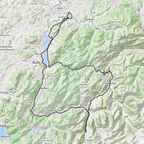
Rowerowa wyprawa na odległość 157 kilometrów z 3036 metrami przewyższenia, prowadząca przez urocze wsie i zapewniająca dostęp do wielu historycznych punktów. Zobacz zamek Mont Chupiaô, bądź zachwycony widokiem na Lac de la Gruyère i wiele innych interesujących miejsc.
road
157 km
3036 m
Wyrypa
Profil trasy
Najważniejsze punkty na trasie
0 km
0 km
Start: Giffers Village centerGiffers: Spokojna lokalizacja dla rowerzystów.
Giffers to lokalność położona w regionie Espace Mittelland w Szwajcarii. Dla rowerzystów oferuje urozmaicone trasy, jednak brakuje tutaj znanych podjazdów czy specjalnych atrakcji dla kolarzy.9 km
9 km
La Combert1082 mSzczytScenic village nestled in the Swiss countryside, offering stunning views of the surrounding area.
15 km
15 km
HautevilleWioskaCharming hamlet with traditional Swiss architecture and peaceful surroundings.
25 km
25 km
Châtel-sur-MontsalvensWioskaHistoric village with a medieval castle ruins and beautiful mountain views.
30 km
30 km
Mont Chupiaô1238 mSzczytScenic mountain summit with panoramic views of the surrounding valleys and landscapes.
38 km
38 km
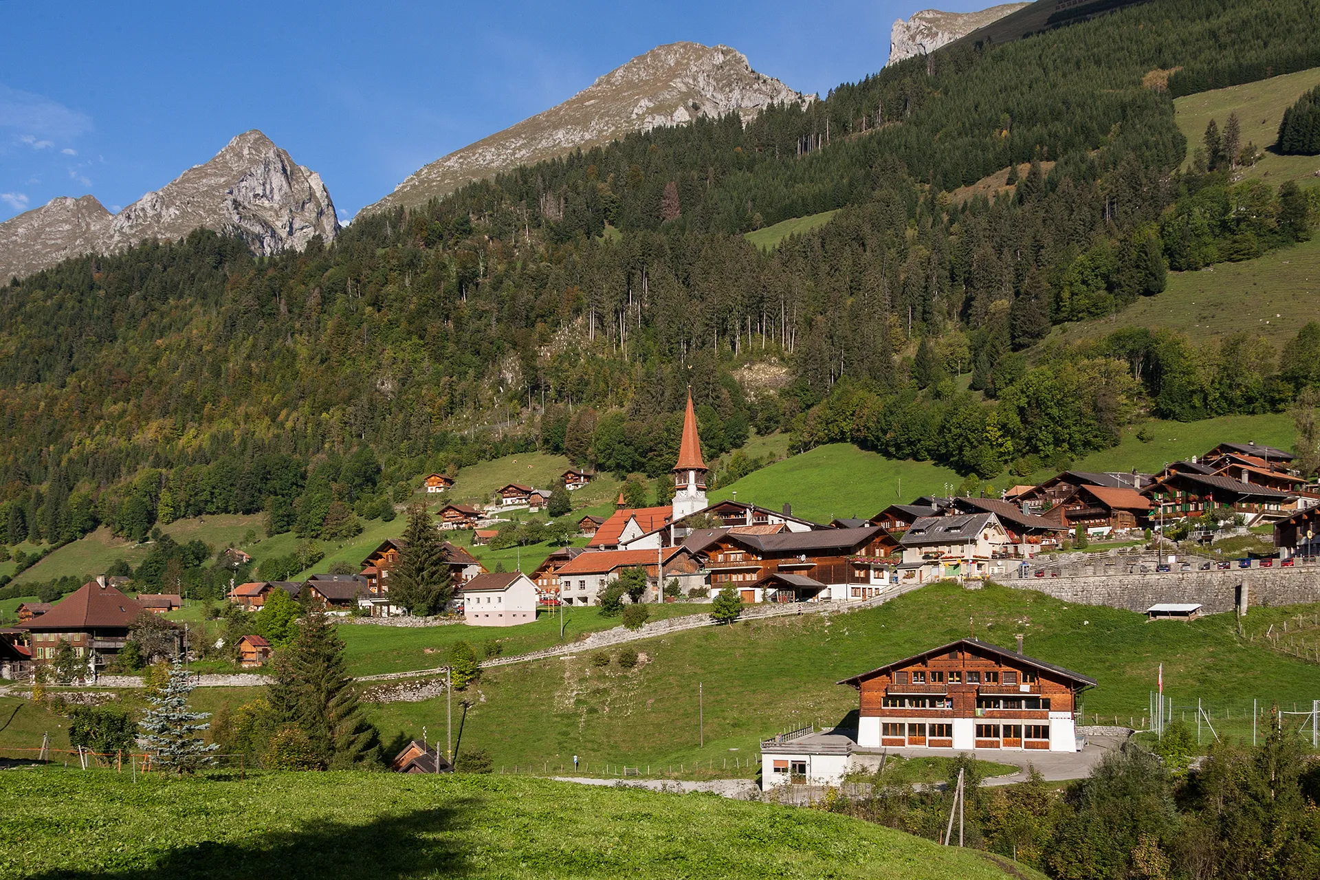
JaunWioskaQuaint village known for its traditional Swiss chalets and stunning alpine scenery.
44 km
44 km
Jaunpass1507 mPrzełęcz górskaMountain pass offering breathtaking views of the surrounding Alps and lush greenery.
58 km
58 km
ZweisimmenWioskaCharming Swiss village with traditional wooden chalets and stunning mountain views.
66 km
66 km
Saanenmöser1279 mPrzełęcz górskaPicturesque village with panoramic views of the Swiss Alps and lush green meadows.
88 km
88 km
Foto-Spot Gstaad SaanenlandWidokScenic spot overlooking the idyllic landscape of Gstaad Saanenland, perfect for photography enthusiasts.
89 km
89 km
SaanenWioskaCharming town surrounded by picturesque mountains and offering a peaceful atmosphere.
104 km
104 km
RossinièreWioskaQuaint village with traditional Swiss architecture, lush greenery, and a relaxing ambiance.
123 km
123 km
GruyèresWioskaHistoric medieval town known for its well-preserved castle, cobblestone streets, and delicious cheese.
123 km
123 km
ViewpointWidokScenic viewpoint offering panoramic vistas of the surrounding valleys and mountains.
132 km
132 km
ÉcharlensWioskaCharming village with traditional Swiss architecture and a tranquil atmosphere perfect for relaxation.
135 km
135 km
Lac de la GruyèreJezioroBeautiful lake surrounded by lush greenery, offering recreational activities and stunning views.
151 km
151 km
Le MouretWioskaScenic village with historic architecture and lovely countryside views.
157 km
157 km
Miejsce docelowe: Giffers Village centerGiffers: Spokojna lokalizacja dla rowerzystów.
Trasy rowerowe z Giffers:
Trasa szosowa z Giffers do Tentlingen Wyprawa do Murten Urokliwa trasa szosowa z Giffers do Plasselb Trasa do Pierrafortscha Długa trasa szosowa z Giffers do Lac de la Gruyère Przejażdżka przez Dolinę Emme Urocza trasa szosowa z Giffers do Plaffeien Trasa rowerowa gravel z Giffers do Fribourg Przejażdżka przez Avenches i Fribourg Poznaj Szlak Fribourg