Yayvantepe to Mağaraköy Road Cycling Route (Extended)
A road cycling route starting from Yayvantepe
Embark on an epic road cycling adventure from Yayvantepe to Mağaraköy (Extended Route)
Map
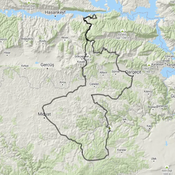
Embark on an epic road cycling adventure from Yayvantepe to Mağaraköy, covering a distance of 192 km with an ascent of 3521 m. This challenging route is perfect for experienced cyclists looking for an unforgettable journey. The highlights of this extended route include Yayvantepe, Midyat, a scenic viewpoint, İzbırak, Anıtlı, and Mağaraköy.
road
192 km
3521 m
Savage
Route profile
Highlights on the route
0 km
0 km
Start: Yayvantepe Village centerYayvantepe: Discover the mix of flat and hilly routes in Yayvantepe.
Yayvantepe is a locality located in the Mardin, Batman, Şırnak, Siirt region of Turkey. The area offers road and gravel cycling opportunities with a mix of terrain. Cyclists can enjoy both flat sections and hilly climbs. There are several well-known cycling spots nearby, such as the Dara Ruins, an ancient archaeological site that can be visited while cycling through Yayvantepe. Overall, Yayvantepe is a suitable locality for cyclists looking for varied terrain and historical sights.0 km
0 km
YayvantepeVillageYayvantepe is the starting point of the route and offers stunning panoramic views of the surrounding landscape.
20 km
20 km
MidyatTownMidyat is a historic town known for its unique architecture and cultural heritage.
21 km
21 km
viewViewpointStop at the scenic viewpoint to enjoy breathtaking views of the surrounding landscape.
42 km
42 km
İzbırakVillageİzbırak is a small village known for its charming countryside and traditional houses.
147 km
147 km
AnıtlıVillageAnıtlı is a small town known for its historical monuments and fascinating culture.
185 km
185 km
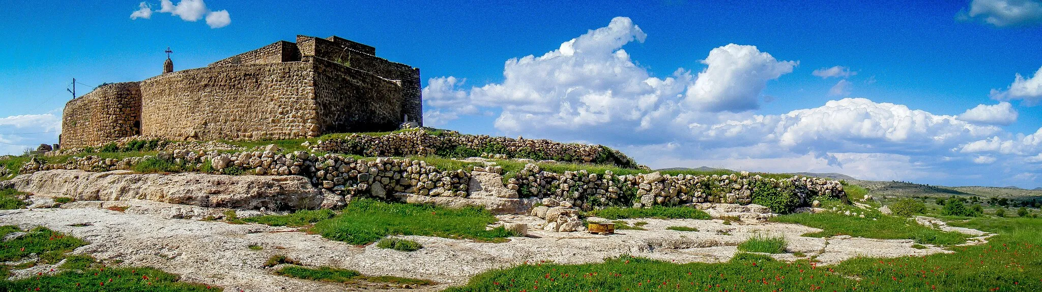
MağaraköyVillageMağaraköy features a beautiful church and offers a serene atmosphere for relaxation.
192 km
192 km
Finish: Yayvantepe Village centerYayvantepe: Discover the mix of flat and hilly routes in Yayvantepe.
Cycling routes from Yayvantepe:
Yayvantepe to İzbırak Scenic Road Ride Yayvantepe to Mağaraköy Road Cycling Route Yayvantepe to Öğündük Loop Yayvantepe to Dibek Dağı Gravel Adventure Yayvantepe to Anıtlı Road Cycling Route Yayvantepe to Midyat Cultural Discovery Yayvantepe to Mağaraköy Road Cycling Route (Extended) Yayvantepe to Altıntaş Nature Escape Yayvantepe to Elbeğendi Gravel Cycling Route Yayvantepe to Nurlu Road Cycling Route