
Jura Heights Challenge
Pyöräilyreitti road alkaen Prangins
Challenging road cycling route offering stunning views and a variety of ascents and descents
Kartta
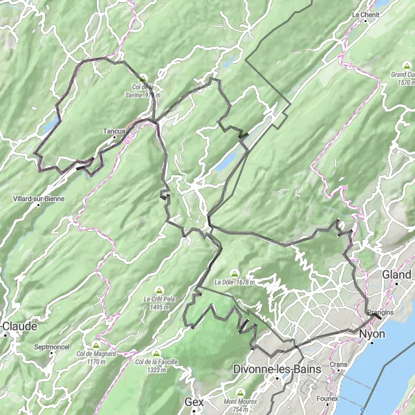
The Jura Heights Challenge is a demanding road cycling route starting near Prangins, Switzerland. With a total ascent of 2780 meters over 139 kilometers, cyclists will enjoy breathtaking landscapes, including the Belvédère de la Bienne and Col de la Savine. The route passes through charming villages like Eysins and Lézat, offering a true taste of the Jura region. As cyclists climb up to Morbier and La Cure, they will be rewarded with panoramic views before descending back to the starting point in Prangins.
road
139 km
2780 m
Kova
Reitin profiili
Reitin kohokohdat
0 km
0 km
Aloitus: Prangins Village centerPrangins: Pyöräilyn mekka
Prangins sijaitsee Région lémaniquen alueella Sveitsissä. Alueella on upeita pyöräilyreittejä, jotka tarjoavat mahtavat näkymät ja haastavia nousuja. Lähellä sijaitsevat kuuluisat pyöräilykohteet houkuttelevat aktiivisia pyöräilijöitä. Prangins on ihanteellinen paikka maantie- ja maastopyöräilyyn.4 km
4 km
EysinsKyläEysins is a picturesque village known for its traditional Swiss architecture and scenic surroundings.
42 km
42 km
PrémanonKyläPrémanon is a popular destination for outdoor enthusiasts, with numerous hiking and cycling trails.
63 km
63 km
LézatKyläLézat is a tranquil village with historic buildings and a relaxed atmosphere, perfect for a pit stop during the ride.
67 km
67 km
Belvédère de la BienneNäköalapaikkaBelvédère de la Bienne offers a stunning viewpoint overlooking the Bienne Valley, providing a perfect photo opportunity.
87 km
87 km
Col de la Savine979 mVuoristosolaCol de la Savine is a challenging mountain pass with winding roads and beautiful alpine scenery.
90 km
90 km
MorbierKyläMorbier is famous for its cheese production, and cyclists can stop to sample local delicacies along the route.
115 km
115 km
La CureKyläLa Cure is a border town between Switzerland and France, offering a unique cultural experience for cyclists passing through.
123 km
123 km
ViewpointNäköalapaikkaThe Viewpoint along the route provides a panoramic vista of the surrounding mountains and valleys, making it a must-see highlight.
139 km
139 km
PranginsKyläPrangins is a charming town located on the shores of Lake Geneva, known for its historic castle and beautiful gardens.
139 km
139 km
Maali: Prangins Village centerPrangins: Pyöräilyn mekka
Pyöräilyreitit alkaen Prangins:
Saint-Cergue Exploration Trail Arzier to Aubonne Gravel Loop Coinsins to Gland Gravel Adventure Prangins - Arzier - Col de la Givrine - Saint-Cergue - Coinsins Chéserex and Tabagnoz Gravel Loop Grand Région Lémanique Road Adventure Prangins - Grilly - Col de la Faucille - Mijoux - Septmoncel - Les Rousses - Saint-Cergue - Trélex Jura Heights Challenge Näkymätön Nyonin reitti Kumpuileva kierros järvenrannalla