Extreme cycling challenge through mountainous terrain
Trasa rowerowa o rodzaju road rozpoczynająca się w miejscowości Rudnik
Test your limits on this epic road cycling route through challenging terrain and breathtaking landscapes
Mapa
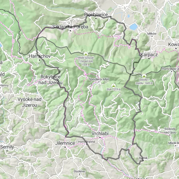
Embark on an extreme road cycling adventure covering 120 km with an ascent of 3159 m, passing through Soví vrch, Dolní Branná, Hrabačov, Preislerův kopec, Ručičky and more. Take on the challenge of Przełęcz Szklarska, Karczmarz, Sobieszów and other tough segments along the way.
road
120 km
3159 m
Trudna
Profil trasy
Najważniejsze punkty na trasie
0 km
0 km
Start: Rudník Village centerRudník: Idealne miejsce do odkrywania pięknych terenów na rowerze.
Rudník to urokliwa miejscowość położona w regionie Severovýchod w Czechach, oferująca piękne widoki i ciekawe trasy rowerowe. Dla miłośników gravelu jest to doskonałe miejsce do eksploracji okolicznych pagórków i leśnych ścieżek. W okolicy znajduje się także wiele atrakcyjnych tras rowerowych dla wszystkich poziomów zaawansowania.0 km
0 km
Soví vrch445 mSzczytSoví vrch is the starting point of this epic journey, offering stunning views and a challenging climb for cyclists.
16 km
16 km
Dolní BrannáWioskaDolní Branná is a charming village with traditional architecture and picturesque surroundings, perfect for a rest stop.
23 km
23 km
HrabačovWioseczkaHrabačov is a small village nestled in the mountains, offering a peaceful retreat for cyclists looking to escape the hustle and bustle of city life.
35 km
35 km
Preislerův kopec1035 mSzczytPreislerův kopec is a challenging climb, with steep gradients and stunning views of the surrounding mountains and valleys.
43 km
43 km
RučičkyWiataRučičky is a hidden gem, with its historic buildings, cobbled streets and charming atmosphere, perfect for a leisurely stroll.
54 km
54 km
Przełęcz Szklarska886 mPrzełęcz górskaPrzełęcz Szklarska is a tough segment of the route, known for its steep gradients and breathtaking views of the surrounding mountains.
62 km
62 km
KarczmarzWidokKarczmarz is a quaint village with traditional wooden houses, offering a glimpse into the local culture and history of the region.
73 km
73 km
SobieszówPrzedmieścieSobieszów is a historic town with a rich cultural heritage, including ancient castles, churches and monuments, perfect for history buffs.
87 km
87 km
Przełęcz pod Czołem819 mPrzełęcz górskaPrzełęcz pod Czołem is a challenging climb, with winding roads and stunning views of the surrounding mountains and valleys.
89 km
89 km
Gravitations-AnomalieAtrakcjaGravitations-Anomalie is a unique geological feature, with mysterious magnetic properties that have baffled scientists for centuries.
100 km
100 km
Lesní hora1129 mSzczytLesní hora is a natural highlight, with dense forests, meandering rivers and stunning views of the surrounding countryside, perfect for nature enthusiasts.
114 km
114 km
Čistá v KrkonošíchWioskaČistá v Krkonoších is a picturesque town along the route, offering a glimpse into the local culture and history.
120 km
120 km
Miejsce docelowe: Rudník Village centerRudník: Idealne miejsce do odkrywania pięknych terenów na rowerze.
Trasy rowerowe z Rudnik:
Trasa Rowerowa do Kovársko Road cycling adventure to Hertvíkovice Trasa gravelowa do Rudníku Trasa Rowerowa do Arnultovice Extreme cycling challenge through mountainous terrain Trasa szosowa przez góry i doliny Trasa Rowerowa do Kamenná Trasa Rowerowa do Nové Kocbeře Wspinaczkowa przygoda w Rudniku Trasa Rowerowa do Dolní Lysečiny
Trasy rowerowe w okolicy: