Eastern Exploration
A road cycling route starting from Karlshorst
Explore the Eastern region of Berlin on this road cycling route
Map
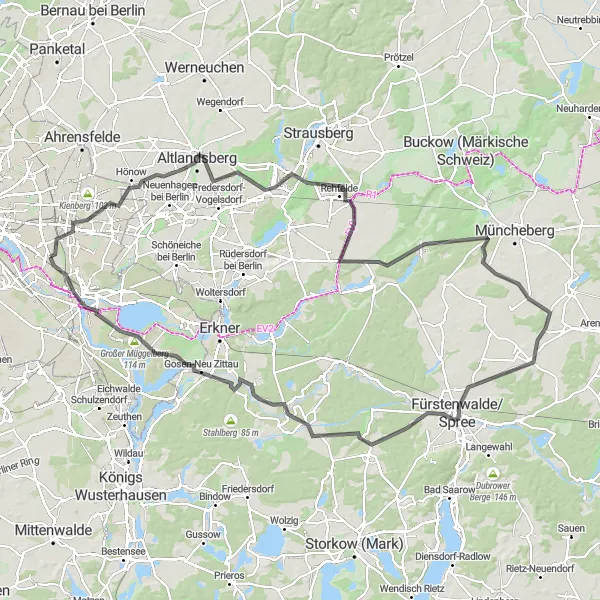
This road cycling route takes you through the Eastern region of Berlin and beyond. With a difficulty level of 4 and a rating of 4 for epicness, this route is challenging and rewarding for experienced cyclists seeking a longer ride. Highlights along the route include Biesdorfer Höhe, Hönow, Rehfelde, Hoppegarten, Steinhöfel, Fürstenwalde/Spree, Biermannsberg, Spreenhagen, Müggelheim, Müggelturm, and Präriehunde. These attractions provide a mix of cultural, historical, and natural sights for exploration.
road
128 km
298 m
Tough
Route profile
Highlights on the route
0 km
0 km
Start: Locality centerKarlshorst: Cycling-friendly locality with urban and natural landscapes.
Karlshorst is a locality in Berlin, Germany. It offers a mix of urban and natural landscapes suitable for cyclists. Road cyclists can explore the city streets, while gravel cyclists can venture into nearby forests and parks. The locality is well-connected to Berlin's extensive cycle path network, making it easy to navigate and explore different areas. Karlshorst and its surrounding neighborhoods also host various cycling events throughout the year. With its cycling infrastructure and diverse cycling opportunities, Karlshorst ranks 3 on the cyclist's perspective scale.4 km
4 km
Biesdorfer Höhe81 mPeakBiesdorfer Höhe is a hill offering panoramic views of the surrounding countryside, a great spot to take a break and enjoy the scenery.
11 km
11 km
HönowVillageHönow is an idyllic village with historical buildings and beautiful landscapes, perfect for a leisurely stroll.
34 km
34 km
RehfeldeVillageRehfelde is a charming town known for its picturesque countryside and scenic trails, inviting cyclists to explore its natural beauty.
50 km
50 km
HoppegartenHamletHoppegarten is famous for its horse racing track, providing an opportunity to witness equestrian sport in action.
71 km
71 km
SteinhöfelVillageSteinhöfel is a small town surrounded by lush green forests, offering tranquility and a chance to connect with nature.
80 km
80 km
Fürstenwalde/SpreeTownFürstenwalde/Spree is a historic city located along the River Spree, known for its charming architecture and riverfront promenade.
83 km
83 km
Biermannsberg67 mPeakBiermannsberg is a hill offering panoramic views of the surrounding countryside, making it a perfect spot to take a moment and appreciate nature's grandeur.
95 km
95 km
SpreenhagenVillageSpreenhagen is a peaceful village surrounded by beautiful lakes and forests, ideal for a serene cycling experience.
115 km
115 km
MüggelheimSub-urbMüggelheim is a charming village with quaint houses and a pleasant atmosphere that is worth exploring.
118 km
118 km
MüggelturmViewpointMüggelturm offers stunning panoramic views of the surrounding landscapes from atop its observation deck, perfect for capturing beautiful photographs.
125 km
125 km
PräriehundeAttractionPräriehunde is a nature reserve populated by adorable prairie dogs, adding a unique touch to the natural scenery.
128 km
128 km
Finish: Locality centerKarlshorst: Cycling-friendly locality with urban and natural landscapes.
Cycling routes from Karlshorst:
Karlshorst-Köpenick Loop Karlshorst-Grünheide Adventure Karlshorst-Bestensee Loop Karlshorst-Gravel Exploration Karlshorst-Cultural Landmarks Landscape Loop Gravel Adventure Eastern Exploration Urban Adventure Nature's Retreat Exploring the Eastern Suburbs Berlin Countryside Tour Gravel Adventure to Köpenick
Cycling routes nearby: