Picturesque landscapes and close to iconic Mont Ventoux.
Cycling routes from Pollionnay
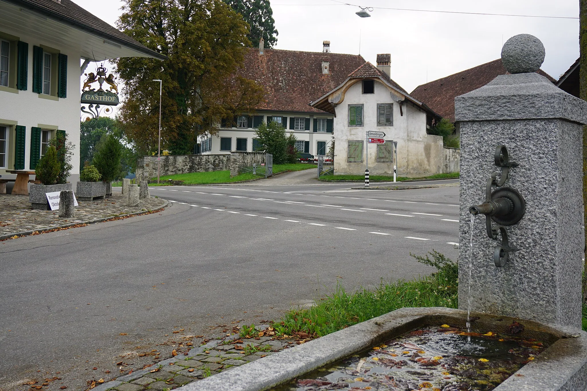
Pollionnay is a locality situated in the Rhône-Alpes region of France. Cyclists visiting Pollionnay can enjoy scenic rides through picturesque landscapes with rolling hills and vineyards dotting the region. The area offers a combination of quiet country roads and challenging climbs, making it suitable for road and gravel cyclists. Additionally, Pollionnay is close to the famous Mont Ventoux, a legendary climb known for its steep slopes and incredible views. With its charming countryside scenery and proximity to iconic cycling locations, Pollionnay is a great destination for cyclists.
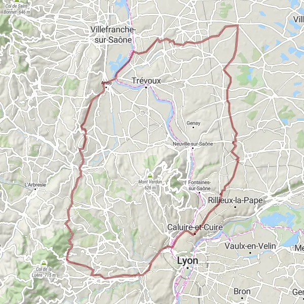
A gravel adventure through diverse landscapes
The Riottier Explorer is a thrilling gravel cycling route that takes you through diverse landscapes near Pollionnay. With a total distance of 90 km and an ascent of 958 m, this route is suitable for adventurous cyclists looking to explore off-the-beaten-path trails. The route starts in Pollionnay and takes you through Saint-Jean-des-Vignes and Riottier, two highlights with unique characteristics and interesting history. As you continue on your journey, you'll pass by Saint-Jean-de-Thurigneux and Château de Cuire, two highlights that offer scenic beauty and cultural significance. Other highlights include Le Belvédère et les lanternes de l'île Barbe, Grézieu-la-Varenne, and finish in Pollionnay, where you can unwind after an exciting day of exploration. Overall, the Riottier Explorer is an adventurous gravel ride that showcases the diversity and natural beauty of the Rhône-Alpes region.
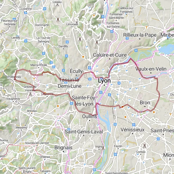
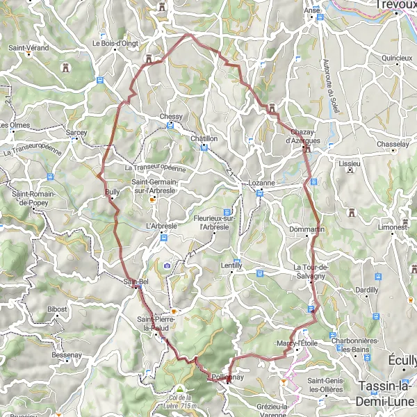
Châtillon to La Rapaudière Loop

A scenic road ride with beautiful vistas
The Châtillon to La Rapaudière Loop is a scenic road cycling route that takes you through the picturesque countryside near Pollionnay. With a total distance of 90 km and an ascent of 1198 m, this route is suitable for experienced cyclists looking for a beautiful and challenging ride. The route starts in Châtillon and takes you through Gleizé, Parcieux, Mont Thou, and Caborne Enfouie, offering stunning views and diverse landscapes. As you continue on your journey, you'll pass by Charbonnières-les-Bains and La Rapaudière, two highlights that offer breathtaking vistas and scenic beauty. Overall, the Châtillon to La Rapaudière Loop is a visually captivating ride that showcases the natural beauty of the Rhône-Alpes region.
An adventurous gravel ride with scenic views
The Gravel Adventure to La Poizatière is an exciting gravel cycling route that takes you through the rugged countryside near Pollionnay. With a total distance of 61 km and an ascent of 584 m, this route is suitable for adventurous cyclists looking for a unique and challenging ride. The route starts in Pollionnay and takes you through Fort Saint-Jean and Place Bellevue, two highlights with historic significance. As you continue on your journey, you'll pass by the Belvédère de la centrale hydroélectrique de Cusset and Passage Comtois, offering stunning views of the surrounding landscape. Other highlights include Aqueduc de Beaunant, Craponne, and La Poizatière, which showcases the natural beauty of the region. Overall, the Gravel Adventure to La Poizatière is a thrilling ride that combines off-road cycling with scenic vistas.

Experience the beauty of Saint-Bonnet-le-Froid
This 67km road cycling route takes you on a scenic loop from Pollionnay to Saint-Bonnet-le-Froid. Along the way, you'll pass by highlights such as Brindas, Saint-Laurent-d'Agny, Saint-Maurice-sur-Dargoire, Table d'orientation, and Ponce. The overall difficulty of this route is moderate, suitable for a well-trained amateur cyclist. With scenic countryside views and some challenging climbs, this route offers a rewarding cycling experience. The epicness of this route is rated at 3 out of 5, providing an opportunity to explore picturesque villages and enjoy the beauty of nature. Highlights along the route include Table d'orientation, a viewpoint offering stunning panoramic views, and Ponce, a charming village known for its rich gastronomy.
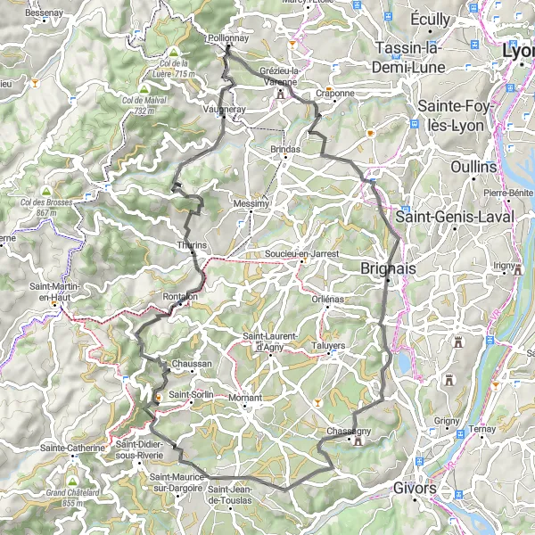
Embark on a gravel adventure to Château de Sain-Bel
This 53km gravel cycling route takes you on an adventurous journey from Pollionnay to Château de Sain-Bel. Along the way, you'll pass by highlights such as Col de la Croix du Ban, Le Breuil, Les Carrières, La Tour-de-Salvagny, and Pollionnay. The difficulty of this route is moderate, suitable for a well-trained amateur gravel cyclist. With a mixture of gravel paths and country roads, it offers a challenging yet scenic ride. The epicness of this route is rated at 3 out of 5, providing a memorable gravel cycling experience. Highlights along the route include Château de Sain-Bel, a historic castle with remarkable architecture, and Les Carrières, former stone quarries that have been transformed into a unique cultural site.
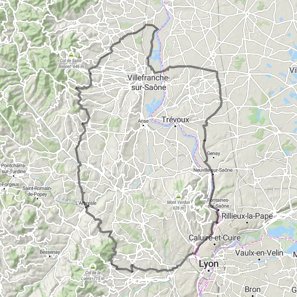
A scenic road ride with diverse highlights
The Pollionnay to Saint-Genis-les-Ollières Loop is a scenic road cycling route that takes you through a variety of landscapes and highlights near Pollionnay. With a total distance of 115 km and an ascent of 1250 m, this route is suitable for experienced cyclists looking for a diverse and challenging ride. The route starts in Pollionnay and takes you through Bagnols and Les Carrières, charming villages with historic buildings and beautiful landscapes. As you continue on your journey, you'll pass by Cogny and Château de Beauregard, two highlights that offer scenic views and interesting history. Other highlights include Parcieux, Fontaines-sur-Saône, and Le Belvédère et les lanternes de l'île Barbe. Overall, the Pollionnay to Saint-Genis-les-Ollières Loop is a scenic and diverse ride that showcases the beauty of the Rhône-Alpes region.
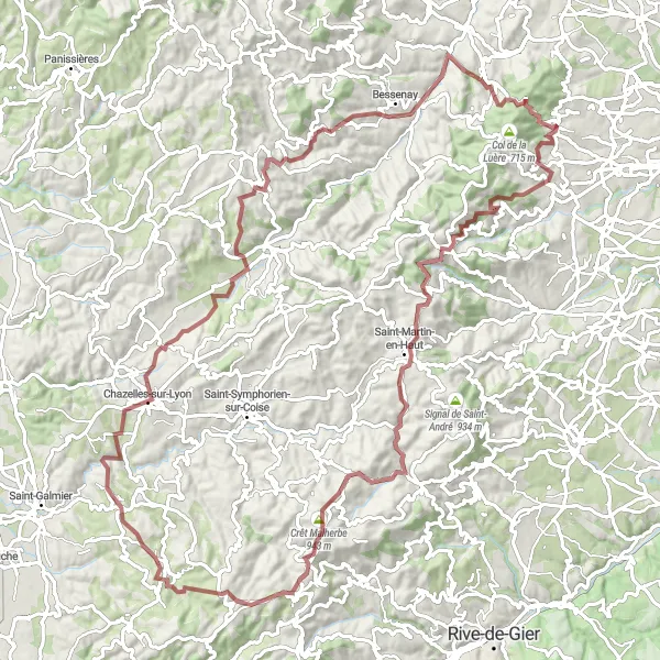
Conquer the challenging gravel route to Saint-Martin-en-Haut
This 101km gravel cycling route takes you on a grueling adventure from Pollionnay to Saint-Martin-en-Haut. Along the way, you'll pass by highlights such as Col de la Fausse, Yzeron, Saint-Martin-en-Haut, Crêt Malherbe, Saint-Médard-en-Forez, Souzy, Brullioles, Saint-Pierre-la-Palud, and Col de la Croix du Ban. The difficulty of this route is high, suitable for experienced gravel cyclists. With challenging climbs and technical sections, it offers a true test of endurance. The epicness of this route is rated at 4 out of 5, providing an unforgettable gravel cycling experience. Highlights along the route include Saint-Martin-en-Haut, a historic village with a medieval castle and charming streets, and Col de la Croix du Ban, a daunting mountain pass that rewards cyclists with stunning views of the surrounding landscapes.
Chaponost Loop
A challenging road ride through beautiful countryside
The Chaponost Loop is a challenging road cycling route that takes you through the stunning countryside near Pollionnay. With a total distance of 68 km and an ascent of 1298 m, this route is suitable for experienced cyclists looking for a rewarding challenge. The route begins in Pollionnay before making its way to Chaponost, a charming village with picturesque views. As you ride through Montagny, Saint-Andéol-le-Château, and Rontalon, you'll be treated to spectacular landscapes and panoramic vistas. One of the highlights of this route is the climb to Crêt de Piralougnon, offering stunning views of the surrounding countryside. Overall, the Chaponost Loop is a scenic and physically demanding ride for those seeking a memorable cycling experience.

Explore the tranquil countryside on your way to Craponne
This 89km road cycling route takes you on a countryside exploration from Pollionnay to Craponne. Along the way, you'll pass by highlights such as Charnay, Notre-Dame-de-Buissante, Chaleins, Civrieux, and Fontaines-Saint-Martin. The overall difficulty of this route is moderate, suitable for a well-trained amateur cyclist. With tranquil countryside views and some rolling hills, this route offers a scenic and enjoyable ride. The epicness of this route is rated at 2 out of 5, providing an opportunity to explore the charming villages and experience the rural beauty of the region. Highlights along the route include Notre-Dame-de-Buissante, a picturesque village with a charming church, and Fontaines-Saint-Martin, a quaint village known for its historic buildings.
From Pollionnay to Montanay
Explore the scenic route to Montanay
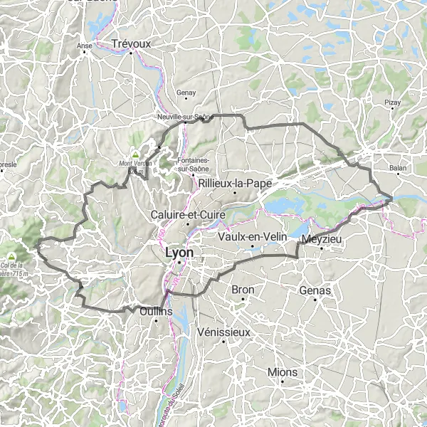
This 100km road cycling route takes you on a scenic journey from Pollionnay to Montanay. Along the way, you'll pass by highlights such as Niévroz, La Jetée, Mini World Lyon, Musée des Confluences, Grézieu-la-Varenne, Limonest, and Mont Thou. The overall difficulty of this route is moderate, suitable for a well-trained amateur cyclist. With a mix of flat and hilly sections, it offers a challenging yet rewarding ride. The epicness of this route is rated at 3 out of 5, providing a memorable cycling experience. Highlights along the route include Montanay, a charming village with historic architecture, and Musée des Confluences, a renowned museum in Lyon.
Cycling routes nearby:


Nearby regions: