Scenic Loop to Saint-Bonnet-le-Froid
A road cycling route starting from Pollionnay
Experience the beauty of Saint-Bonnet-le-Froid
Map

This 67km road cycling route takes you on a scenic loop from Pollionnay to Saint-Bonnet-le-Froid. Along the way, you'll pass by highlights such as Brindas, Saint-Laurent-d'Agny, Saint-Maurice-sur-Dargoire, Table d'orientation, and Ponce. The overall difficulty of this route is moderate, suitable for a well-trained amateur cyclist. With scenic countryside views and some challenging climbs, this route offers a rewarding cycling experience. The epicness of this route is rated at 3 out of 5, providing an opportunity to explore picturesque villages and enjoy the beauty of nature. Highlights along the route include Table d'orientation, a viewpoint offering stunning panoramic views, and Ponce, a charming village known for its rich gastronomy.
road
67 km
1225 m
Tough
Route profile
Highlights on the route
0 km
0 km
Start: Pollionnay Village centerPollionnay: Picturesque landscapes and close to iconic Mont Ventoux.
Pollionnay is a locality situated in the Rhône-Alpes region of France. Cyclists visiting Pollionnay can enjoy scenic rides through picturesque landscapes with rolling hills and vineyards dotting the region. The area offers a combination of quiet country roads and challenging climbs, making it suitable for road and gravel cyclists. Additionally, Pollionnay is close to the famous Mont Ventoux, a legendary climb known for its steep slopes and incredible views. With its charming countryside scenery and proximity to iconic cycling locations, Pollionnay is a great destination for cyclists.6 km
6 km
BrindasVillageBrindas is a historic village known for its medieval architecture and charming streets.
17 km
17 km
Saint-Laurent-d'AgnyVillageSaint-Laurent-d'Agny is surrounded by beautiful vineyards and offers a peaceful break for cyclists.
27 km
27 km
Saint-Maurice-sur-DargoireVillageSaint-Maurice-sur-Dargoire is a picturesque village with traditional houses and a tranquil atmosphere.
32 km
32 km
Table d'orientationViewpointTable d'orientation is a viewpoint offering breathtaking panoramic views of the surrounding countryside, including the Mont d'Or and the Rhône Valley.
37 km
37 km
Signal de Saint-André934 mPeakSignal de Saint-André is a hilltop landmark that provides scenic vistas over the rolling hills of Rhône-Alpes.
51 km
51 km
YzeronVillageYzeron is a charming village known for its historic buildings and beautiful hiking trails.
58 km
58 km
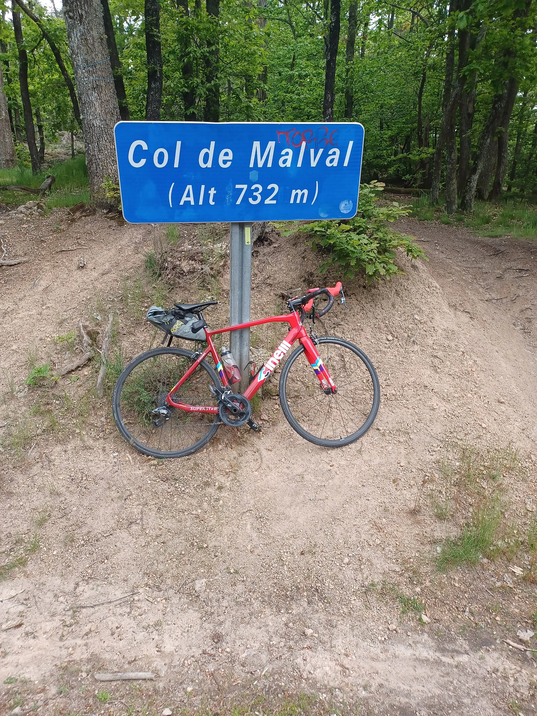
Col de Malval732 mMountain PassCol de Malval is a challenging climb that rewards cyclists with stunning views of the surrounding Alpine landscape.
60 km
60 km
Saint-Bonnet-le-FroidHamletSaint-Bonnet-le-Froid is a charming village known for its gourmet cuisine, making it a must-stop for food lovers.
65 km
65 km
PonceHamletPonce is a beautiful village surrounded by nature, perfect for a picnic or a leisurely stroll.
67 km
67 km
Finish: Pollionnay Village centerPollionnay: Picturesque landscapes and close to iconic Mont Ventoux.
Cycling routes from Pollionnay:
From Pollionnay to Montanay Gravel Adventure to La Poizatière Gravel Adventure to Château de Sain-Bel Countryside Exploration to Craponne Grueling Gravel Adventure to Saint-Martin-en-Haut Riottier Explorer Chaponost Loop Pollionnay to Saint-Genis-les-Ollières Loop Scenic Loop to Saint-Bonnet-le-Froid Châtillon to La Rapaudière Loop
Cycling routes nearby: